|
I wrote this article to raise awareness of free, offline, OpenStreetMap-based topographic maps and show how to use them on smartphones, computers and Garmin hand helds. It was only after I'd finished that I thought it might be better to include something on digital mapping from the Ordnance Survey too. So the included OS mapping information was added retrospectively. Geoff Moss.
OpenStreetMap is the 'Wikipedia of mapping'. It is an amazing resource that's completely free to use. It is helpful to understand a little about OSM mapping but if you'd rather just try an OSM map out on your favourite device then jump straight to Getting started. There are now excellent free topographic maps based on OpenStreetMap data, that cover many of the places we fly, both here in the UK and abroad. The OSM maps are viable alternatives to Ordnance Survey maps and government funded maps in other countries too. Most can be stored on smartphones, tablets, Garmin hand helds and computers. Even if you are a card-carrying technophobe, just switching an app on is enough to show exactly where you are on a stored map, away from any phone signal. Your position is typically shown by an arrow on the map which will point in the direction you're moving. Some of the best maps and apps are completely free.
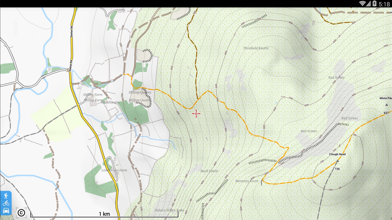
Thinking about flying off the summit of Mont Blanc? OpenTopoMap shows the popular routes up. Looking for a restaurant, pharmacist or cashpoint in an unfamiliar town? These are shown or named on OSM maps. Maybe you just want to find the wooded shortcut up Clough Head, an offline OpenAndroMap does the job. Flight computer app XCTrack uses OSM based OpenAndroMaps and OSM data is probably behind the proprietary mapping for other flying apps too. The best OSM maps don't require huge amounts of storage and a detailed topo map of the UK could live permanently on your phone. Unless money's mentioned, the OSM apps and maps discussed here are free.
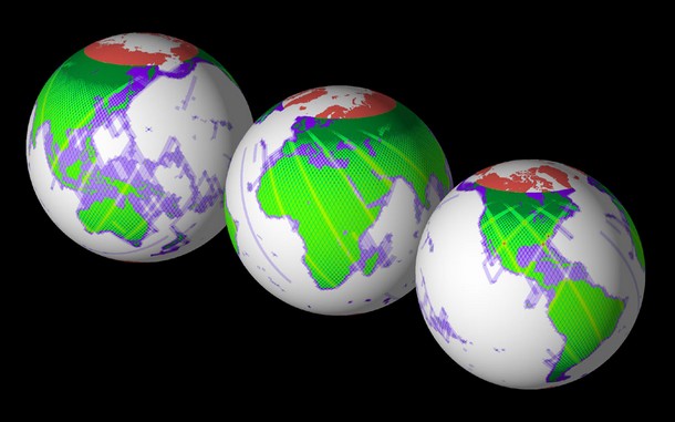
OpenStreetMap's mission is to map the planet and make all the related data publicly available and free to use. It was launched in Britain in 2004 and using a crowd-sourced model like Wikipedia the project has been phenomenally successful. A huge number of different contributors and various methods are used to help make OpenStreetMap. eg Surveying by mapping professionals, satellite aerial imagery, publicly available government agency data and GPS info from ordinary map users. Contours are generated using free data supplied by NASA.
Many of the locations we travel to are already very well mapped. The map is always improving as it's constantly being developed, updated and checked by the OSM community. I love the collaborative ethos and it has spawned many great OSM based resources. l OpenStreetMap l FAQ l
OpenStreetMap based tools are often encountered online. eg Here in the UK OpenTopoMap was used for the 2018 paragliding Northern Challenge Trophy tasks. Some apps can copy sections of online OSM based maps, to be permanently stored on the phone.
So when you head for the hills, no internet or phone connection is required to provide a map, it's already safely stored on your device.
Most smartphones made after 2007 include a GPS chip. These phones can all process signals directly from the Navstar GPS satellite constellation to show exactly where they are on a stored map. The phone doesn't transmit anything. A GPS smartphone can determine it's location anywhere on the planet with an accuracy of roughly ±15m. New phone GPS chips for 2018 promise even better accuracy. Amazing. It's true that some data capable of improving GPS performance can reach a phone via a phone signal or wifi connection, but none are needed. These extras just refine the position or help speed it's acquisition. The wifi and cell phone connections really can be switched off. Non-essential extras... l A-GPS l DGPS l GLONASS l WAAS l
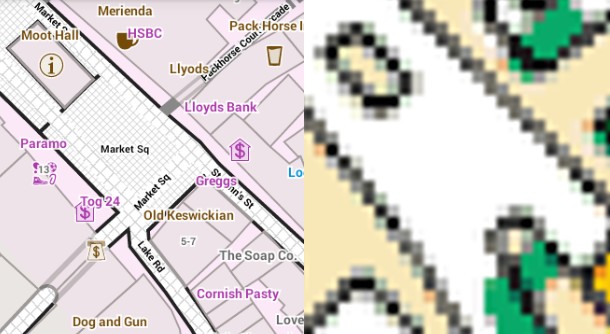
The GPS accuracy that we tend to take for granted relies on space age technology where the timing precision required is absolutely astonishing... l The Ordnance Survey explain raster and vector maps l On YouTube l 2m 24s l Big file sizes and several maps at different fixed scales needed. These are simple to understand. A raster map is basically an image, like a photo of a paper map. Zoom out a long way and you won't be able to read it as the detail becomes too small to see. Zoom in and it will get bigger on the screen, like magnifying a paper map, until eventually you'll start to see the tiny pixels that make up the image. Zooming in and out requires switching between maps at different scales. Memory Map supply digital OS maps in four different map scales. 1:25,000, 1:50,000, 1:250,000 road map and a 1:1 million overview. Displaying images doesn't make great demands on a smartphone so raster maps should work well. However recording millions of pixels in raster map images takes a lot of data and the files are big. 1:25k maps of the UK from Memory Map need a phone-filling 11GB. If you fancy the high definition maps a spare 41GB is needed for the 1:25k and 1:50k maps.
One map can do it all. A vector map may only need a fifth as much data as the identical map in raster format. The map can be scaled to any size without sacrificing image quality. Unseen data offers other advantages over raster maps. The excellent OpenAndroMap of Great Britain is about 1GB. If you were to vol biv across the Alps you could easily take the vector OpenFietsMap of the entire Alps from Slovenia through Austria, Italy, Germany, Switzerland and France. It's just under 2GB and it's free. There is also a great vector OpenAndroMap of the Alps that is less than 2GB and Talky Toaster offer the Alps too.
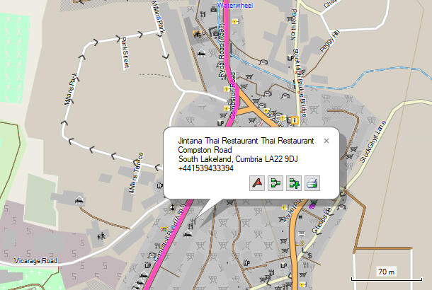
With a microSD card in your hand held device, unlike the current Brexit negotiations, it's easy to have the whole of mainland Europe in your pocket. The map elements of which OpenStreetMap is made are stored as a list of points, lines and areas. A single point might be a telephone box, park bench or cash point. A road or river may be defined by a series of points and an area like a field or building can be defined by a series of points where the last point is the same as the first. The positions of the points are precisely described by their latitude and longitude. Points, lines and areas are accompanied by unseen tags. These describe exactly what the points, lines and areas represent. They may also include routing information and provide other useful information too. The tags list can be long and include ordinary stuff like addresses, telephone numbers etc. There are even a dozen or so tags for free flying. eg Clicking a restaurant icon on an OSM-based map may access unseen tag information. You could learn that it serves Thai food, get the postal address and telephone number too.
l Beginners Guide l
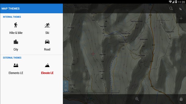
Vector maps allow the look of the map to be easily changed. When a vector map is browsed the app must convert map data to a screen image on-the-fly. Should a road be red or yellow? Should contours be visible? What font sizes to use? These things are defined by a map style or theme (better). If you're good with Microsoft's 'Word' then you'll be familiar with styles and themes. A 'style' technically refers to a specific map element. The theme is a set of styles that covers everything in the map. The Locus Map phone app comes with four internal themes (City, Hike & Bike, Road, Ski) that may be applied to any offline mapsforge vector map. External theme files can also be used to customise maps. OpenAndroMaps offer an external 'rendertheme' file (Elevate 4). Each theme has many map elements that may be switched on/off to taste in the app's theme settings. Theme files are little and quickly installed. The image below looks like two different maps but the halves are from a single map file, just with different options selected in the app. A road and hiking map in one.
Perhaps you'd like text and map icons to be bigger to help your ailing eyes? That sort of thing is possible with many apps and even humble Garmin hand helds offer basic customisation of vector maps. The processing power required to convert vector map data to an on screen map image might cause an older device to work more slowly. Software can make some OSM vector maps look a bit ugly but they're better maps than they look and they offer flexibility. I guess a few of us have had a road map in the car, an 'A to Z' for town centres and OS Explorer maps for the hills. Vector maps can perform all of those functions and will also do routing...
A routable map is one that contains all the information required for the host device to work out a good route between two points. Car sat navs and Google Maps use routable vector maps. OSM maps too. OSM vector map tags can contain unseen information about road speed limits, one-way streets, cycle tracks, paths etc. A device can read this and work out good routes for different forms of transport. Another vector map trick.
It's possible to get OSM vector maps that don't include the routing information. This reduces file size without removing any of the visible map. eg There is a routable (675MB) and non-routable (422MB) version of Talky Toaster's free British_Isles topo map.
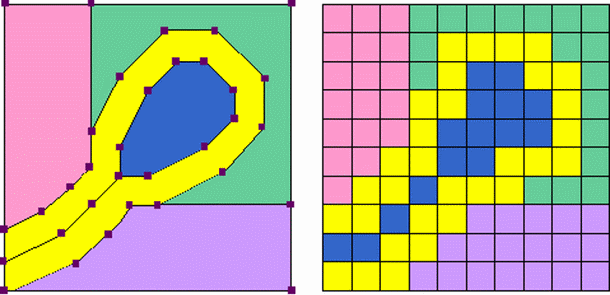
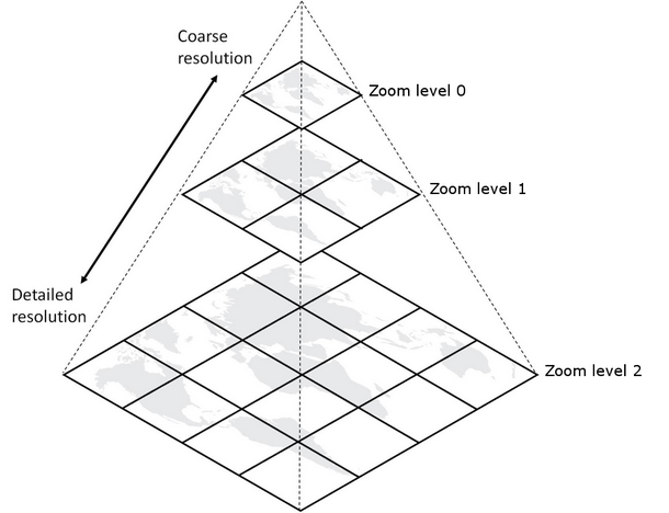
Nearly all the apps that provide offline copies of online OSM maps do so by downloading image 'tiles' and storing them on the device. Online maps like OpenStreetMap and OpenTopoMap are made available to our web browsers by providing the vector map data as small square images. It's these 256 x 256 pixel images that are known as tiles.
The correct scale should always be shown on an OSM map because it varies both with 'zoom level' and location on the planet. The way the curved surface of the planet is represented by the flat OpenStreetMap causes regions nearer the poles to get stretched more (Mercator projection). eg For any location that's 60 degrees north (roughly the northern tip of mainland Scotland) or 60 degrees south, a pixel represents only half the distance of a location at the equator (maths here). However the mercator projection is perfect for navigation as it preserves angles. Try this... go to OpenStreetMap, grab anywhere north of Scotland and drag it southwards. Keep your eye on the scale to see how it varies. Unlike the continuously varying scale, angles can be relied on. You could travel on a fixed bearing taken from the map, for thousands of miles and arrive at your destination. An OSM map has Zoom Levels not a fixed scale. At zoom level '0' the mercator-projected world fills one 256 x 256 pixel square tile. The dimensions double with each subsequent zoom level and the world expanded to fill all the tiled squares.
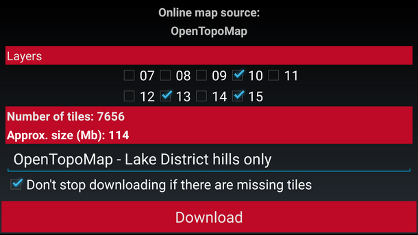
If image tiles are downloaded to provide an offline raster map that offers all the zoom levels, a completely different tileset is needed for every zoom level. The file size will be enormous compared to a vector map of the same area. However navigating through hills doesn't require tiles for the highest zoom levels. The iOS app MotionX-GPS makes it possible to select a zoom range before downloading a map. Oruxmaps displays the available zoom levels which can be individually selected before downloading the map.
Downloading image tiles is not all bad news, it does ensure the map will look identical in any app and look good at every zoom level. How an offline vector map looks will vary a bit depending on the app and theme settings. A vector map may also look better at some zoom levels than others.
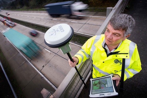
For practical purposes the accuracy of OpenStreetMap is only limited by the quality of the supplied data. OpenStreetMap records latitude and longitude coordinates to 7 decimal places. This locates the points that define map features with a maximum error of about ±6mm. A professional surveyor armed with a Global Navigation Satellite System (GNSS) receiver can measure to a few centimetres.
Someone may add information to OpenStreetMap that is just plain wrong. That must happen sometimes, but like Wikipedia it can be spotted and corrected by the OSM community.
Although it's not practical for individuals armed with GPS units to map contours, OSM based topo maps do still contain accurate contours, thanks to NASA. 'NASA' contours or 'SRTM' contours (same thing) are often mentioned on OSM based topo map download sites without any more clues as to what their limitations might be. Here's a bit more information... In 2000, for eleven days, NASA used the Space Shuttle to survey most of the planet and collect detailed land elevation data. The technique used could 'see' through clouds (radar interferometry) and the project was called the Shuttle Radar Topography Mission (SRTM). They didn't survey Antarctica or anything north of the Shetland Islands but 95% of the planet's population live in the surveyed area. In 2015 NASA made the collected data freely available and free to use.
NASA's data is available as height files (.hgt). Each file covers an area on the earths surface that is 1 degree of latitude by 1 degree of longitude. 'Lifewire' explains how the file names describe the area covered by each file. These files are also sometimes called DEM files - 'digital elevation model'. An 'hgt' file basically contains a very long list of spot heights arranged in a grid. It's possible to generate accurate contours from these files and apps will use the data for other height related functions too.
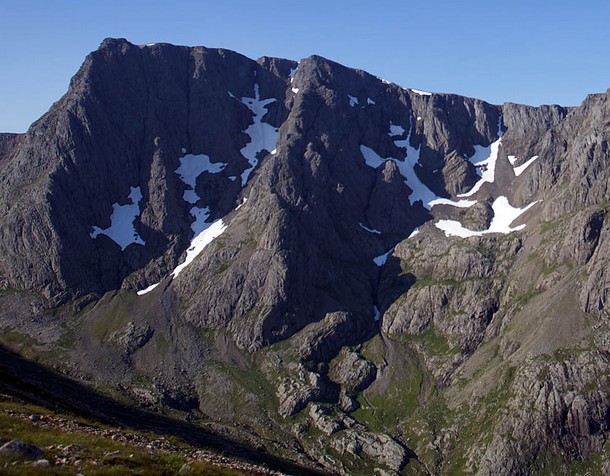
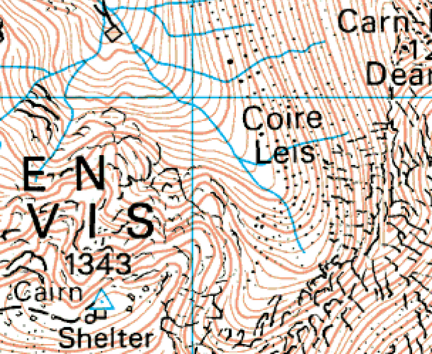
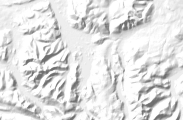
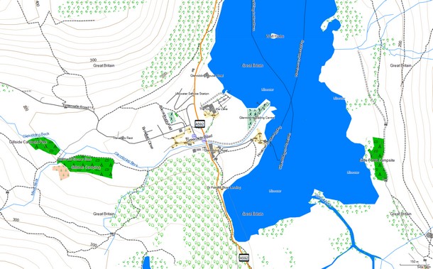
However the original NASA data has some areas where the shuttle struggled to get good information. Those areas are known as 'voids' and include spots in places like the Himalayas where the ground is high and steep. So, other open sources of good contour data have been used to augment NASA's work and 'fill in the gaps'. Map makers can use these void-filled versions of the NASA data freely. Jonathan de Ferranti of ViewfinderPanoramas.org has drawn on many data sources to improve the SRTM data and adds areas that weren't even surveyed by the shuttle mission. His work may be freely downloaded via his map at ViewfinderPanoramas. Some apps download these files directly (eg Locus Map, Oruxmaps, Alpine Quest and Cartograph) to provide a hillshading overlay, altitude information, 3D views of the maps, route elevation profiles and more. NASA's freebie 30m resolution data can't model sharp changes nearly as well as a 5m grid from the Ordnance Survey. That difference in contour detail between OS and SRTM data is apparent in the maps. See the Ben Nevis extracts next...
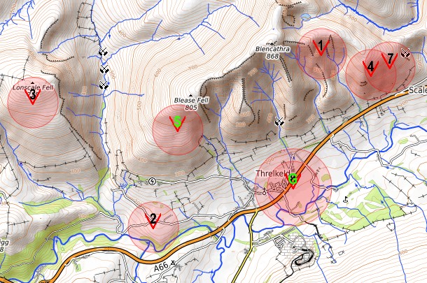
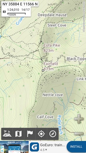
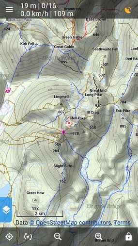
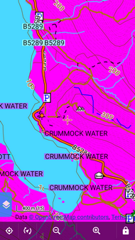
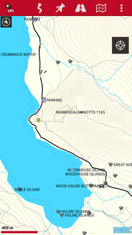
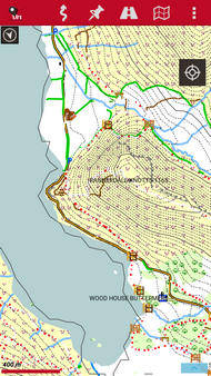
Although OSM maps are accurate, in mountainous areas the amount of recorded detail is currently not as good as in high quality OS-type topo maps. Conveniently this is not the case with OSM paths. These are likely to be from walkers tracklogs and they are uncannily accurate. Although there will be paths on OS maps not yet marked on OSM maps there are also paths and trods shown on OSM maps missing from OS maps. See Lonscale Fell on an OS 1:25k map and an OSM map
On the 1:25k OS map crags, scree, rocks and grassy areas are all marked. It's clear that the ridges running up either side of the summit will not provide easy walking. With a 10m contour interval, it's just the practicalities of printing at this scale that limits what's shown.
The OpenMTB map with 20m contours has hill detail typical of OSM topo maps.
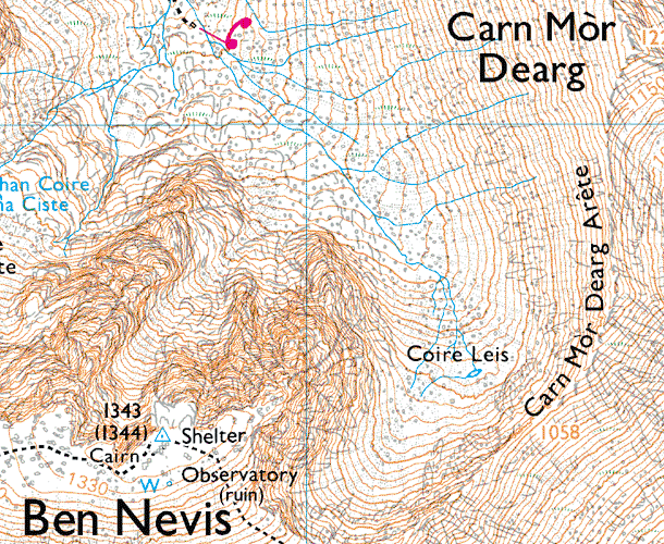
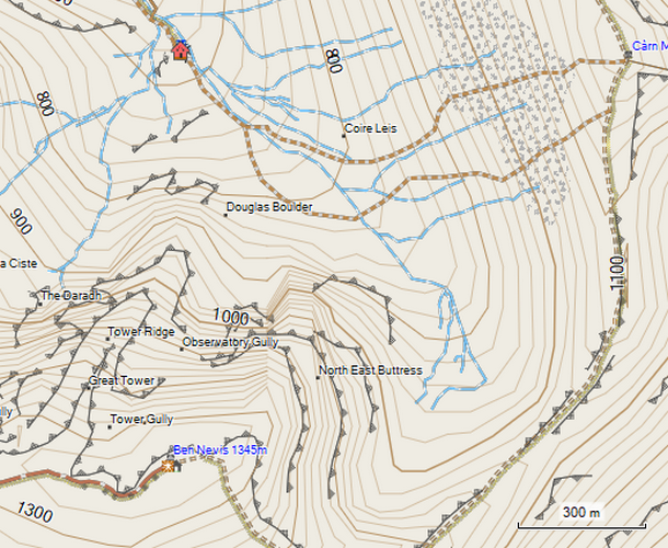
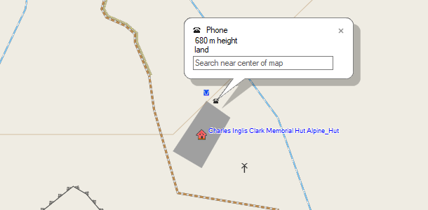
The nature of the ground underfoot is mostly missing. The crag markings warn of difficult terrain but you could be forgiven for thinking a zig zag walk might get you up. On the plus side there are details not on the OS map. Two paths are marked to the summit of Carn Mor Dearg, the walk around the CMD arete is shown and if you're a climber you will appreciate the labelled mountain features. Zooming in to the building symbol reveals some information only available in the OSM map. The 'CIC' hut is correctly named. Symbols indicate drinking water, a phone and a wind turbine.
The craggy terrain is still better represented in this 1:50k OS map than in the OSM freebie. Hopefully the future will bring further improvements to OSM mapping of craggy hills.
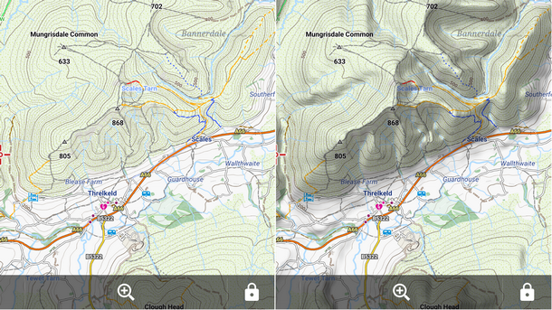
'Hillshading' describes the shadows that would be cast over the ground if the sun's rays were shining over it. Although not essential, it does help quickly judge the lie of the land. Here in the UK we're used to the sun shining from the southern half of the compass but maps work much better placing an imaginary light source to the north west. We like our shadows under things. The topography can appear inverted with the light source placed at the bottom of the map.
Online OSM maps often have hillshading (eg OpenTopoMap) and apps that download image tiles will provide these maps offline exactly as they appear online. No problem. However greyscale shadows are hard to represent with vector data. To solve this, an extra layer of semi-transparent shadows must be placed above a vector map. The mostly transparent overlay bumps up storage requirements but a vector map plus hillshading overlay still takes up much less space than a raster map equivalent.
Height files make it possible to provide almost any altitude related info, offer 3D views of the maps and vary the intensity of hillshading with zoom level. Zoom in using Locus Map and the hill shading gets lighter with each zoom level. This helps avoid obscuring fine detail with darker shadows. An advantage of a separate hillshading layer is that it may be applied to any 'flat' map of the same area. The familiar paper OS Landranger and Explorer maps don't have hillshading but it is now offered with the digital versions from Memory Map. High quality hill shading for the UK needs a modest 250MB (roughly) worth of .hgt files.
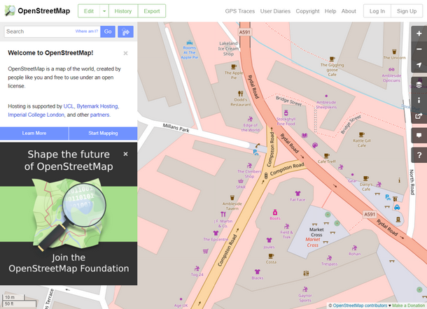
Anyone can login to the OpenStreetMap website and edit the map instantly via an easy to use interface. An edit will be visible online shortly afterwards and will appear soon on any regularly updated OSM based maps. Updating an OS map is not so easy. You can use your own GPS tracklogs to map things or 'trace' over the aerial imagery provided by the editing interface. Dedicated editing software is also available and there are mapathons and mapping parties to attend! Get started with the OSM beginners wiki or this LearnOSM tutorial.
The ability to update the map instantly can be particularly useful in disaster zones. Earthquakes and hurricanes can change a region overnight. There is a Humanitarian OpenStreetMap Team (HOT) dedicated to helping out. Given geo-referenced aerial photography a team of mappers can quickly re-map a devastated area.
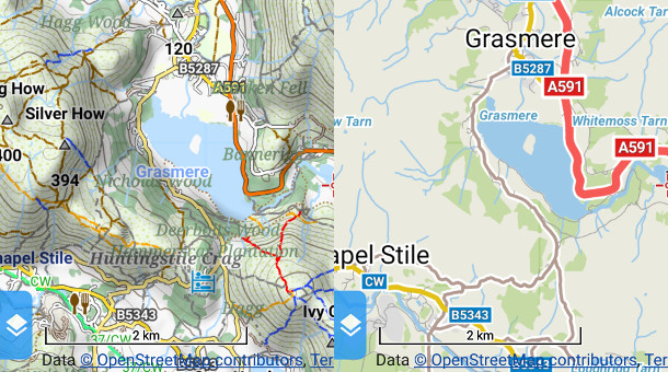
It's difficult to know how well an area is mapped, a weakness of OpenStreetMap. A surprising number of countries have maps made for them. Try trawling the list of map download sites below. However the standard of coverage for different places will vary significantly. Much OSM mapping is crowd-sourced so if an area has poor internet connectivity it's less likely to be well mapped. OSM began in Britain. Mapping looks good here and a few popular free-flying destinations that I've browsed in western Europe appear well covered. OSM based maps can rival maps from Google and government funded bodies in those well covered areas. Try comparing up to 8 different maps at once with this clever tool. The link shows two OSM based Thunderforest maps (top) and two familiar Google products (bottom). Where's the path compares the OS 50k and older 25k maps with a range of maps. There's a bit more comparing via these links... It would be a good idea to compare OSM maps with an example of a local government funded topo map before heading off on a Himalayan vol biv armed with OSM map, iPhone and cereal bar. This video celebrating 10 years of OpenStreetMap (2004 - 2014) shows data being added year by year. It gives an idea of where the OSM hotspots are. l On YouTube l 1m 36s l Even less fun to watch but this video shows data added up to 2018.
There are many and lots are proprietary. Independent OSM map makers mostly provide offline maps in just two vector formats, mapsforge (.map) and the Garmin format (.img). Both are easy to use as everything about the map is contained in a single file. There aren't many 'prebuilt' OSM maps offered in raster formats but if an app will import raster maps there's a good chance it will use the mbtiles or sqlite formats. Free desktop software MOBAC can produce those. For information on OS maps go to the Ordnance Survey section.
Purpose built to use OpenStreetMap data, mapsforge is the favourite vector format for Android devices. However a few apps allow this format to be used on iOS and desktop computers. The data is converted to a map image on-the-fly by the app and vector efficiency means a good topo map of the whole UK weighs in at a manageable 1.1GB.
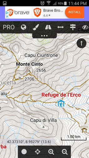
Some of the best OSM-based maps are the mapsforge maps supplied by OpenAndroMaps. They combine the topo detail found in OpenTopoMap with the detailed town information of the main OpenStreetMap. Jiri Mlavec, the main developer, is a paraglider pilot
These maps look good at every zoom level and downloading an additional small 'rendertheme' file, provides four map theming options: Hiking, City, Cycling and Mountain Bike. Each theme may be tweaked to fine tune what's seen on the map. The rendertheme is a once only download and the options it provides can be applied to any OpenAndroMaps. It's OpenAndroMaps that provide the basemaps for popular flight computer app 'XCTrack'. This provides it's own theming options to customise the maps specifically for in-flight use. The same map file can be used by XCTrack and a conventional map app on the same device.
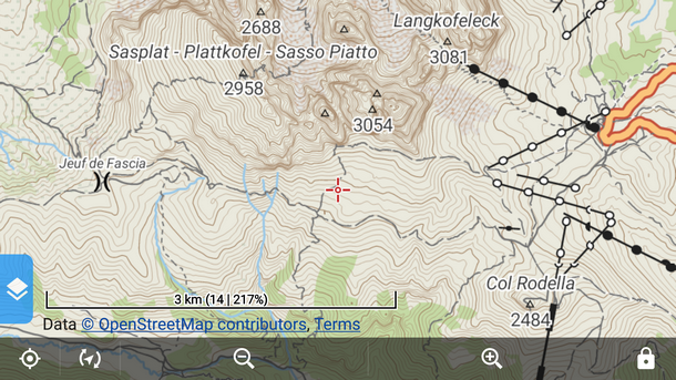
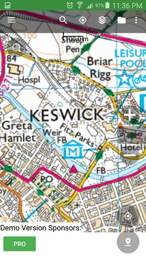
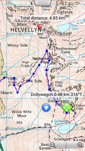
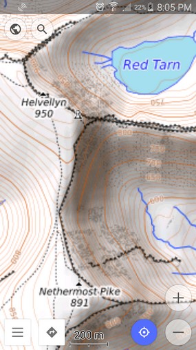
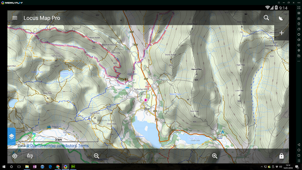
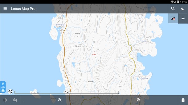
Here are some OpenAndroMaps screenshots of Cumbria, centred on Ambleside. Taken from Locus Map with the current Elevate 4, hiking theme.
Garmin have not published details of their proprietary format but years of reverse engineering have got it pretty well sussed. Perhaps as a consequence, there are now free tools available like mkgmap, that enable anyone to make Garmin compatible maps from OpenStreetMap data. There are many websites offering free Garmin format topo maps. The .img map files can be placed straight onto a Garmin or an Android smartphone. Garmin's free 'BaseCamp' allows use of these maps on a desktop computer (Windows or MAC OS).
However I can't find an iOS app that supports Garmin files.
Typically at a website that provides Garmin compatible maps, a few files are offered. One will be a single ready made '.img' file that can be placed straight onto a Garmin hand held or smartphone. The other options will be Windows and MAC installers that put the same map into Basecamp. The uncluttered look and light background on Talky Toaster's free British Isles map works well for getting round our hills and OpenTopoMap's 'Garmin Edition' maps look a bit like our familiar OS maps. Occasionally 'contours only' is a map download option. Apart from the contour lines these maps are normally transparent and could be added to a matching contour-free map (they must both use the identical map projection). OpenTopoMap/Garmin Edition supplies two files, the map without contours and a contour-only .img layer as well. Both must be enabled in a Garmin hand held to see the complete map. Oruxmaps can combine these two separate layers within the app.
These Garmin compatible maps aren't 'locked' and you don't need a Garmin account or subscription. Just put one on your device and go. Here are BaseCamp screenshots of some Garmin format OSM maps from different independent providers.
MBTiles and different flavours of the SQLite format are commonly supported. These formats allow the huge number of image tiles that make up a raster map to be stored and moved around as a single file. They make it possible to display just a few tiles at a time from the thousands that may be stored within the file and are a good choice for digital versions of traditional paper maps. eg The Spanish CNIG maps are all available in the MBTiles format. When an app stores tiles downloaded from an online map like OpenTopoMap or Thunderforest Landscape it may use one of these formats. Tiles based raster formats ensure a map looks identical on all platforms.
Advantages Disadvantages
Advantages Disadvantages
l Importing prebuilt maps l In-app downloading l MOBAC l
Choose your favourite OSM map maker and download a single file. Simple. This is a fast and reliable way of obtaining good OSM topo maps. By 'prebuilt' maps I mean ready made maps in a non-proprietary file format, not accessed directly from within an app. Any app that understands the format should be able to use the map. There are quite a few independent map makers offering free OSM based vector maps for much of the planet. Putting a downloaded map into a Garmin or app normally just requires the file to be placed in the right folder. Dedicated installers are provided for Garmin's BaseCamp maps. Uniquely, OpenAndroMaps provide 'quick-install' buttons which make installing their vector maps in supported apps almost as easy as in-app map downloading (next section).
If you want to stick with a favourite map app that only imports raster maps then MOBAC can generate good raster maps from OpenAndroMaps vector files. eg Here are downloadable raster maps of the Cumbria and Dales areas generated by MOBAC and Locus Map. Unusually all the CNIG Spanish 'paper' maps are freely available in various forms including the 'MBTiles' format for smartphones.
2. In-app downloading Selecting maps from within the app is the most convenient way of downloading maps but not all in-app download methods are good. The most common in-app downloading method involves retrieving tiles from online maps to store for offline use. Apps generally offer a way of selecting an area to download. They then try to download and save the selected image 'tiles' from the online map. In my experience, the associated issues with this particular method make it of limited value. Many apps will only download small areas at a time. In the past, many users bulk downloading tiles for large areas has put an unwelcome strain on OSM map servers. Slippy map tiles are designed to be viewed a few at a time in web browsers, not bulk downloaded in their thousands for offline use. Some apps were banned. Downloading tiles is also slow and not all the tiles may be retrieved. File sizes are really big for any given area.
The following four online maps are commonly available to download and all show paths and contours. With a light background OpenTopoMap is probably favourite. Downloading tiles might be OK if you just want a small area (I'd still check for missing tiles) but a non-starter for downloading a country or large region. Not all in-app map downloads retrieve raster tiles. Unusually, OsmAnd offers in-app downloading of OsmAnd vector topo maps. This is convenient and works well.
This desktop software provides an easy way to produce custom raster maps from online and offline maps (.map vector and raster). It doesn't create vector maps. MOBAC will view online maps and download image tiles just like a phone app. It can also use locally held map files as map sources. Although it won't produce vector maps it will successfully use a mapsforge vector map as a source. It's best as a raster map creator or format converter. It will export selected areas of any displayed map in many different raster file formats. The export format options include 'Garmin custom maps' suitable for compatible Garmin hand helds as well as many other raster formats for a wide range of phone apps.
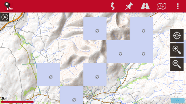
l MOBAC screenshot l It's possible to add extra suitable online maps to MOBAC. A special text file must be added to it's 'mapsources' folder which tells MOBAC what the desired map's website address is and how to retrieve the tiles. Unintuitively, adding locally stored map files is done in the same way. I'll keep files for extra maps so they may just be downloaded and placed in MOBAC's mapsources folder. eg There's a text 'xml' file to add OpenTopoMap to MOBAC and instructions on how to add a local map file. MOBAC suffers from the usual tile downloading issues when getting online maps but is OK for small areas. However those problems go away if the map source file is stored on your computer. eg A locally stored OpenAndroMaps mapsforge vector map makes a great source file and will allow the generation of raster maps for usefully large areas. Which zoom levels are included can be specified in MOBAC. A MOBAC produced OpenAndroMap raster map of the area shown below may be downloaded here.
l MOBAC l MOBAC quickstart manual l Map sources files l
If you have a slow/flaky internet connection or want to download a huge ready made map file then consider using a download manager. If there's a problem that interrupts a download you don't have to start all over again. A download manager will keep a partially downloaded file and finish the download when all's well again. Try Free Download Manager (Windows or MAC). Here's a review. Even vector maps are big files. UK - 1GB, Alps - 2GB, Western Europe - 10GB. To check your connection speed - click 'GO' at this speedtest website.
l Alpine Quest l BackCountry Navigator l Cartograph l Gaia GPS l See Getting started for my recommendations. However you might not be looking for the same functionality or be curious why I've recommended those particular apps. So the above links are to summaries of the apps I considered most. The summaries follow a few paragraphs on 'desirable features'. This isn't a complete list of all the apps available but I hope it includes most of the better ones. Apart from the Memory Map app (no OSM support), as an absolute minimum, all of the apps summarised here offer GPS navigation with offline OSM topo maps and if they're Android will access map files on an added microSD card. Some apps do a lot more. Let me know if you've got a favourite you think should be here.
• Display GPS location on a stored topo map when offline.
A raster OSM topo map of the UK, that included all the zoom levels, would be a very large file indeed. Yet hardly any apps offer in-app downloading of good OSM vector maps which make it perfectly possible to have the whole of western Europe stored on a phone. So the ability to import external, prebuilt vector maps is extremely useful. Raster file support is good for using converted traditional paper maps (eg OS maps) and smaller areas of online maps copied for offline use.
Smartphone screens often have more pixels than a TV or computer monitor. A map designed to work well on a 24 inch monitor can be hard to read on a 5 inch phone screen. If you don't have hawk-like eyesight, being able to make the map bigger is really useful. You might think zooming in would help? Whilst your fingers are still on the screen, an OSM map may automatically switch to the next zoom level, making everything too small to see again. Apps offer up to four different tools that can help. Few apps have all these tools, some have none. They're called a variety of different things in the apps but will be one or more of the following...
Garmin hand helds also allow customisation of vector map elements. Detail shown, hill shading, text size for points, street labels, etc
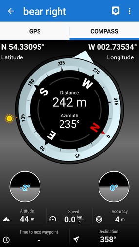
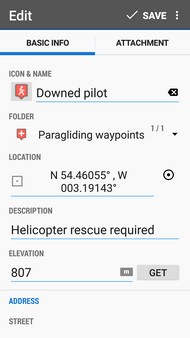
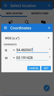
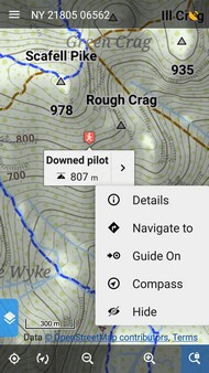
Locating a downed pilot from coordinates or giving your own position using coordinates could be invaluable in an emergency. A Garmin inReach satellite messenger will give it's position using Lat/long (WGS84 datum) and this is the coordinate system most widely supported by apps. Better apps will also offer OS grid refs and other coordinate systems as well. Not all apps can place markers or identify locations using coordinates.
Navigating with a phone screen can require a lot of zooming out (and back in again) to check progress. A highlighted or marked route removes this need. Some apps can mark a route quickly and easily. GPX is the most widely supported file type for sharing routes, waypoints etc.
• AlpineQuest GPS Hiking website
Alpine Quest is very unusual in it's support for the old style OS Memory Map files (the .qct files are not encrypted). If you can get hold of the old 'V5' mapping then this app offers a very cheap way to get OS maps on a smartphone. It can also download from a range of online OSM maps. Thunderforest Landscape is OK for hill use.
BackCountry Navigator app (Android only. Free and Full version £11) • BackCountry Navigator website
It's a capable app and the free version is not very hobbled, so if you can bear the advert then the app is quite usable. It will import both prebuilt vector and raster maps. There are quick-install buttons for this app at OpenAndroMaps. The Great_Britain OpenAndroMap seems to work more slowly in BackCountry Navigator than it does in Locus Map. The full version of 'BCN' is more expensive than the excellent Locus Map but both the 1:50k and 1:25k OS maps are viewable if online and they can be downloaded in-app for offline use, at no cost. The OS maps are supplied by Bing Maps and BCN's 'Bing License Key' currently allows the app to access the maps. To my surprise even the free demo version downloads the OS maps. However, it is limited to relatively small areas at a time, more suited to hill walking (about 25 x 35km). I guess the full version may not offer any more. The app could be easier to use but does try and address this with pop-up 'help' boxes for some functions. The boxes can be permanently dismissed individually as needed.
Cartograph Map Viewer app (All main platforms, Lite and Pro version £5) • Cartograph Map Viewer website
Superseding Vectorial Map from the same developer, it might be the only app that works across all of the main platforms, smartphones and computers (iOS, Android, Windows, MAC OSX). All versions use an almost identical interface. Cartograph is a good app focused on offline use using imported external maps. The ability to import prebuilt topo vector maps (.map) is particularly rare for iOS. Even the free Lite version works with OpenAndroMaps and their quick-install buttons make adding maps a breeze. Cartograph will also import maps in common raster file formats SQLite and MBTiles too. So Cartograph will use the excellent free CNIG Spanish maps and any maps that MOBAC can produce from online or offline sources. Handy. With no in-app map shop it's not possible to easily get commercial mapping on this app. eg OS, IGN, Swiss topo maps etc. A 'Goto coordinate' button will immediately put map centre crosshairs at entered coordinates. Map centre coordinates can be displayed on the screen and similarly it's no problem to use coords to add/edit markers. The current version only uses lat/long. No OS grid or any other coordinate systems. It will view, but not download, a small range of online maps. OpenTopoMap and the main OpenStreetMap are available. More online maps can be added but not easily. Techie help is currently required (see the Cartograph YouTube tutorials and documentation). A live tracking function can share location via GPSies or a custom web server. l Cartograph YouTube tutorials l Documentation l
Gaia GPS app (iOS and Android £16) • Gaia GPS website
It's pricey for an app but unusually Gaia comes with an online mappy ecosystem. Free registration gives good access to some of that. An associated account will sync favourite maps and plan, store or sync routes. Good OSM topo maps are offered. I think the marriage with the online account is better suited to planning hikes. Gaia say unlimited map downloading is possible but forum posts explain that their map tile suppliers do impose download limits. There are two subscription options and premium membership at £35/year includes access to IGN France and Swiss Topo maps. Gaia can't import any prebuilt external maps. The free version doesn't allow map downloads and £16 doesn't buy an amazing app. Gaia have their own OSM Gaia topo map for outdoor used based on the American USGS map style. The standard app only uses raster maps but the new version with a gold border offers the Gaia topo map as a vector map. l Gaia GPS l Macworld review l Bikepacker review l Adventure nomad review l
Locus Map app (Android only. Free and Pro version £6) • Locus Map website
It comes in two versions, Free and Pro. The free version offers unlimited use of the key functions if you can put up with the narrow banner ad. I was unable to resist the lure of the freebie but was very quickly convinced and only 5 minutes later had coughed up £5.99 for the 'Pro' version. Banner ad banished and no hobbled functions. It's ideal for mapsforge vector maps and raster formats too. Many formats are supported. Additionally the in-app 'Locus Store' gives access to a great range of free and commercial maps including OS, IGN, CNIG, Swiss Topo etc. Many online OSM maps can also be viewed and downloaded. Locus Map is supported by OpenAndroMaps quick-install which makes adding their maps simple. See Getting started (Android) for instructions on how to do that.
Unusually, Locus Map can download relatively large areas of online OSM maps successfully and it's possible to accurately select the area to taste. To avoid overloading the map provider there is a limit to the number of tiles that can be downloaded in a day. Request more than the daily limit and Locus Map manages the full download over many days. A 'point' can mark a location with lat/long coords from an inReach satellite device. OS grid refs may be entered also. Once created, Locus Map will share the points details via other apps on the phone eg text, email, whatsapp etc. The phone's coordinates are also easily displayed at the top of the main screen in the chosen coordinate system.
It's no problem having a close look at maps. Locus Map has all four tools mentioned in map readability. The Locus Map zoom lock is great, all apps should have one, it makes the displayed vector map behave like a fixed image. Tap the lock button at any zoom level then zoom in as close as you like, nothing resizes. Which controls show on screen can be customised to taste. The screen can be all map with a double tap to call up user selected controls or have many controls visible. It has very good GPX route tools and tapping the screen will manually create an easily edited route. It can also instantly auto-route along every twist and turn in hiking paths. Setting a start point and destination is enough to get an efficient route accurately drawn on the map. A setting allows it to call on online routing service GraphHopper, or if offline, Locus Map can use free app BRouter invisibly in the background to provide routing. Locus Map even offers basic live tracking. It is an amazingly good app. Too many more features to mention here...just try it
l Locus Map l YouTube tutorials l
Memory Map app (Android and iOS) • Memory Map website
This app can't use any OSM based maps at all but if you're considering using OS maps on your phone then this app is a good one. It will only use maps in Memory Map's proprietary formats. These include CAA VFR charts. Although the app is good for the UK and Memory Maps are also available for France, this app doesn't travel very well. Memory Maps are not available for countries all round the world. Powerful apps like Locus Map have more whizzy features but I've used the Memory Map app for years and am quite happy with it. It does the basics well enough. All Memory Maps are raster maps, so if something's hard to see, just zoom in to make it bigger. The app has a setting option which can automatically change maps when zooming. It doesn't always change scale exactly when you'd like it to, but does avoid tedious manual switching. It's OK. It's easy to work with coordinates and markers. A global setting determines if locations are displayed in Lat/Long or OS grid. Routes may be quickly tapped out and points fine tuned afterwards. The app will share GPX files of the markers and routes via the apps on the phone. The Memory Map platform comes with desktop software which can take a plain map image, calibrate it and convert it for use with the software and app. This means you could scan, photo or otherwise obtain an image of any map and get it into Memory Map. The desktop software adds the necessary geo-referencing and converts the image to a Memory Map file format. I suspect few users will bother as this isn't a speedy process and it does require the purchase of an 'Import Third Party Maps license'. However this does offer the ability to get almost any map into Memory Map, if there is sufficient will!
• Oruxmaps website
It's probably the only phone app that does a good job with Garmin (.img) files and displays OpenAndroMaps (.map) files perfectly too. So this app probably gives access to more prebuilt vector maps than any other single app. OpenAndroMaps provide dedicated quick-install buttons for Oruxmaps so installing their maps is very simple.
The 'Default zoom' setting can make maps up to 400% bigger and the volume control can give further locked-zoom magnification whenever required. Very good. Placing markers with entered coordinates is quick and the phones coords are easily called up. The manual route creation tool works well and GPX files are competently handled. Although just adding a map is enough to start navigating it's possible to customise the app interface. The screen may be full of controls or all map. Appropriate taps can reveal different controls when needed. Many other tweaks are available. Oruxmaps is less intuitive to use than Locus Map. If you can't resist ticking the 'advanced preferences' box then get comfortable first. Some time and experimenting is required to get the app how you'd like. There's a free version (on website) and a donate version (Play store £2.59). Both are advert free and even the free version is fully functional. Curiously the current latest version (7.2.14) is not available on the Play store because "it violates the payments policy". However it's easy to install the latest version by visiting the Oruxmaps website then downloading and using the APK installation file. This app is both great and free, but it's flexibility and power make it harder to use. I don't think it's possible to edit a previously saved or imported GPX file and it can't access commercial maps like OS maps.
OsmAnd app (iOS and Android. Free, pay for extras) • OsmAnd website
OsmAnd is an 'open source' project with offline OpenStreetMap based vector maps at it's heart. A powerful map app that's been around a while. It is currently THE OpenStreetMap specialist and a cheap app to run. However, a separate app is needed for access to commercial mapping like OS, IGN, Swiss topo etc. It offers easy in-app downloading of good quality topo vector maps (a cheap plugin is needed to add contours and hill shading). Download large regions at a time. Several regions are available for free which are enough to get most of mainland Britain. It travels very well and mapping for countries all over the world are available. Countries are sub-divided into smaller regions. You can download these instead of the whole country, if phone storage is short. The UK maps have great detail and can be styled for the chosen activity. Topo or Offroad 'map styles' make paths easily visible on a light background and crag markings are shown. The maps can be themed to be anything from detailed topo maps to continent crossing road maps to inner-city maps with Google-Maps-like street details. Although it won't import external vector maps, it will import SQLite raster files that MOBAC can generate. A large range of online maps can be viewed within the app and OpenTopoMap is one of them. There's good help on how to use the app at the OsmAnd website and there are quite a few third party tutorials kicking about on YouTube etc. It's a bit slow going at first working round the menus/options/settings and plugins but once set up it's a great navigation app. l OsmAnd l Import raster maps l Wiki l
The following link to brief summaries of Basecamp l Cartograph Map Viewer l Cruiser l
Garmin's BaseCamp is proper desktop software and free. It offers an easy way to start using offline OSM topo maps on your computer. It's only possible to use ready made maps in the .img Garmin format but there are many websites that supply these. Although it has a quirk or two, it works well enough.
Running a downloaded map installer is all that's required to get a map into BaseCamp. You can install as many maps as you like, for anywhere in the world. OpenFietsMap offers a free 10GB download that installs the whole of Europe in one go.
Basecamp offers the full range of paper sizes and can print a grid of sheets (up to 4x4) to cover a large area. A0 (about 33 x 47 inches) is an option. A 4x4 A0 grid with Talky Toaster's free British Isles map and PDFCreator can produce a detailed map of the Lake District.
BaseCamp offers several ways to alter how map detail is displayed. 1. Detail level: A drop down toolbar menu with 7 levels (low to highest) is a coarse control that quickly changes the level of detail displayed at any zoom level. 'Lowest' keeps things snappy if dragging the map around zoomed out. 2. Activity profiles: A long list of check boxes can be ticked or unticked to theme the map (Edit/Options). Planning a road trip? Create and save an activity profile that switches all the contours, paths and mountain peak icons off. If you want to see absolutely everything offered at a particular location then have a different activity profile where all the check boxes are ticked. A drop down menu allows saved 'activity profiles' to be switched instantly. This can also affect how the software creates routes between locations if you use the auto-routing. 3. General settings: In 'Options' there are several global settings where you can choose text font/size, symbol size, fewer/more labels, track widths, route widths and rendering quality. 4. 'Overlays': Routes and tracks can be shown or hidden as required. If you download OS maps using the 'Birdseye' download option they appear as overlays and not in the map menu. One of the software's quirks.
Cartograph Maps Pro for desktop (Windows, MAC OS, iOS, Android £5) This works on computers and smartphones. It might be the only app that will display vector mapsforge maps on a desktop computer at the same time as offering a suite of other mappy tools. It works well with OpenAndroMaps. It also supports the use of MBTiles and SQLite raster maps so will work with maps generated by MOBAC. It will create/edit and import/export gpx tracks. It offers online map viewing. OpenTopoMap and the main OpenStreetMap are included.
It runs fine in Windows/MAC without needing JAVA. The interface is obviously aimed at a mobile device so requires a little more mouse work than regular desktop software. I have the Windows version and the map does not look as sharp as it does in other apps. Lat/long only, no OS grid. On my computer it crashes occasionally but mostly it's fine and does the job. There's a little more info in the Cartograph phone app summary. l Cartograph Map Viewer l Cartograph tutorials on YouTube l
Cruiser desktop software (Windows, MAC OS and Linux) If you want a simple fast viewer for mapsforge vector maps, this is it. It can add hill shading instantly and allows access to the map theming options. It also displays the OpenStreetMap online standard map and 'humanitarian map'. It has a standard desktop software layout and is familiar in use.
Although it will import a gpx route/track file and display it on the map it's not possible to create or edit one. It's really just a map viewer. Cruiser needs JAVA so won't run on a computer that doesn't already have JAVA installed on it. Windows doesn't come with JAVA pre-installed and not all MACs have it pre-installed either. l Cruiser l Cruiser screenshot l
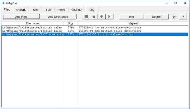
GMapTool desktop software (Windows, OSX, Linux) This can merge or split Garmin .img files. eg It can merge a 'contours only' .img file with a contourless map file to a make a single .img map with contours included. It will also take a single gmapsupp.img map file intended for use on a Garmin handheld and split it for use in Basecamp.
The splitting process generates all the required files including installation and uninstall files. Running the installation file will put the map into BaseCamp. Some maps are only provided for Garmin handhelds so it's handy to be able to convert them for use in BaseCamp too. GMapTool also allows basic editing of a few other .img properties like how the map name appears on the device. l GMapTool l
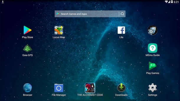
Locus Map on a desktop using an emulator Locus Map is designed for Android but it can be used on a desktop computer fairly easily. If the emulator offers a 'full screen' option then any sign of the emulator, or desktop OS, disappears. The app fills the screen. A mouse works fine with the MEmu emulator for Windows and a touch screen is not required. Recommended. MEmu was the emulator I went for after seeing a post on the Locus Map website and a bit of extra Googling. It was 269MB and aimed at ordinary consumers, it downloaded quickly and installed easily. When MEmu is run for the first time you'll need to enter your Google account details. That made me nervous but nothing bad has happened yet! If you're concerned about security you could just set up an extra free GMail/Google account for the job. Conveniently MEmu comes with the 'Play' store already on the home screen, so installing apps is simple. Use the 'Play' store just as you would on a smartphone. MEmu is easy to use and works well with Locus Map.
I use Windows so haven't tried these. 'Bluestacks' is mentioned on the Locus Map website and seems to be a popular free Android emulator. It is available for MAC OS and Windows. Bluestacks l Bluestacks review l l Android emulators for MAC OS and Windows l
MOBAC - Mobile Atlas Creator, desktop software MOBAC makes custom raster maps in many file formats. MOBAC can use a locally stored ready made OpenAndroMap to produce raster map versions for a variety of mobile apps. It will also make raster versions of online maps too. MOBAC is summarised more fully in the Maps section of this article.
QMapShack desktop software (Windows, OSX, Linux) QMapShack is full desktop software that works with Garmin maps. I've not tried this alternative to Garmin's Basecamp. I think it's probably good. The software sprung from QLandkarte GT and has years of development behind it.
Vectorial Map desktop app Vectorial Map is from the same developer as Cartograph. The developer pointed me at his newer Cartograph which supersedes Vectorial Map.
l Android phones l iPhones l Garmins l Computers l Here are step by step instructions and some video tutorials to help get started with a good OSM map on the above devices. Here's some information for OS maps.
A reliable way to get a good OSM based topo map is to download a prebuilt map from an independent map maker. Data efficient vector maps are offered by many websites for countries all round the world. Putting these onto smartphones, Garmin hand helds and computers is usually easy. OpenAndroMaps are the best free vector topo maps that I've found and with the right app they can be used on Android, iOS, Windows and MAC OSX. For Garmin hand helds the Talky Toaster free British Isles map is very good. l About OpenAndroMaps - Screenshots l When putting a map onto a smartphone or Garmin then the internal storage is the most reliable place to store the map. However if your device is short on space or you want to carry the whole of western Europe with you then you can place the map on an inserted microSD card, if you have one.
Get the excellent Locus Map app from the Google Play store (free or Pro version). If interested you can really delve into the differences between the two. Get a map from the OpenAndroMaps website where there are quick-install buttons specifically for Locus Map. These make installing maps and a rendertheme (currently 'Elevate 4') easy. The rendertheme is a once only download that allows maps to be themed for different activities. The website has good install instructions or try this short video tutorial. l On YouTube l 3m 24s
These instructions are correct for Locus Map Pro version 3.31.3 (Aug 2018) Once Locus Map and the rendertheme have been successfully installed, open Locus Map and near the bottom tap the little blue 'Left actions panel' tab and then tap Map Themes. Choose Elevate LE and select Hiking from the drop down menu at the top. This ensures contours and paths are visible. Lose the annoying green diagonals over national parks by unticking 'Borders and special areas'. Now tap anywhere on the map to dismiss the panel. Done.
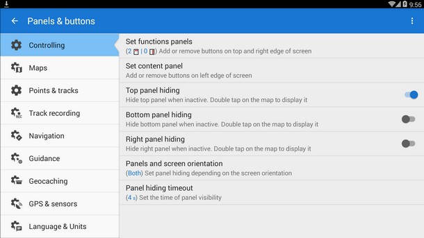
Tap the menu icon top left, choose Settings and highlight Controlling. Tap 'Panels and buttons'. Now play with the options till you're happy. I like to keep the bottom panel visible with a double tap to reveal the top panel. That always keeps the most useful controls available whilst keeping the rest of the screen for the map. Setting the 'Panel hiding timeout' to a few secs should work. Done.
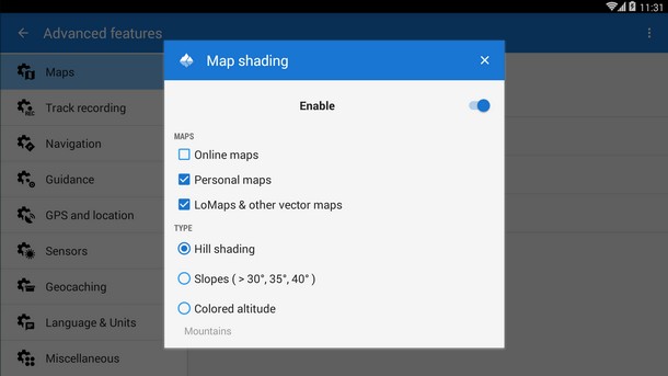
Hill shading in Locus Map By no means necessary but a 'nice to have'. If you want hill shading it must first be enabled in Locus Map. Tap the menu icon top left then choose Settings/Maps/Advanced features/Map shading. Set the Enable switch to 'on', tick Personal and vector map check boxes and leave the radio button on 'Hill shading'.
l About Cartograph l About OpenAndroMaps l First download a version of Cartograph 2 from Apple's App store. A free 'Lite' version comes with a banner ad and many hobbled features but will still allow GPS navigation with OpenAndroMaps. It won't allow editing of theme 'layers' as described in the video below or offer hillshading. At £5 the 'PRO' version is a bargain to have full access to these maps. Once the app is on your phone you can install an OpenAndroMap.
The Cartograph website has good install instructions and this short video tutorial also covers map/theme installation with a little more on how to theme the map.
This is easy to add and shows the lie of the land well. First zoom in/out so that the region you want hill shading for is on the screen. Then tap the 'world' icon and choose 'download elevation data'. Cartograph now downloads and stores the necessary height files which allow the app to calculate a hill shading overlay. To actually enable the hillshading then tap the world icon again and choose 'Manage maps'. Now tap the menu icon to the right of 'Offline hillshader' and choose 'Add as overlay'. It might be necessary to reload the map and/or overlay to get it working. The reload options are accessed directly via the world icon at the top. The height files may be downloaded manually from viewfinderpanoramas and added to the appropriate Cartograph folder for the same result.
Place a downloaded and suitably named .img file onto a Garmin and it will be good to go. It's that simple. The plain light background and 10m contours in the Talky Toaster free map work well for hill use and the map looks better on a hand held than it does in BaseCamp. eg wooded areas appear as brown cross hatching in BaseCamp but as green tree symbols on a hand held eTrex 20x. Alternativas Libres, OpenMTB and OpenFietsMap also offer good free maps for many countries worldwide.
There are some older Garmin hand helds like the 60, 76 or 96 still in use and the odd newer model too. The older Garmins are fussy about what the map file is called and newer hand helds aren't. I'll start by explaining how to put a map on a newer one 'cos they're really easy then move onto the older ones which aren't much harder.
You will need a computer, the USB lead and the Garmin. What happens with a Garmin eTrex 20x is described below. It will be the same process for similar units of the same generation. The USB chips in Garmins are very slow. If you're in a hurry then put the Garmin's microSD card into a computer's card reader and transfer the file directly to the card. Then there's no need for the Garmin at all and data transfer will be much quicker. • Name the map file sensibly but leave the .img suffix alone. NB. The map name appearing on the Garmin is determined by the file content not your given file name. If the new map doesn't appear it's possible that you've got an older Garmin...
The older Garmins can only read a single map file which must be called gmapsupp.img. That single file can contain several different maps or just one. The 76csx is an example of an older Garmin and the process below will be similar for other units of that era. There's a slow way to add an extra map and a quick way. 1. Quick way
l On YouTube l 2m 38s • Plug the Garmin into a computer and put it into 'USB mass storage mode' 2. Slow way l Garmin list of models and year l
Three options - 1. Garmin's Basecamp, 2. Locus Map + emulator, 3. Cartograph 1. BaseCamp is Garmins free desktop mapping software for Windows and MAC OS and uses Garmin .img maps. It won't work with any other map format. First run the software installer from Garmin. Then you can add a free map of the British-Isles from Talky Toaster. The Talky Toaster download page includes installers (MAC and PC), installation instructions and video tutorials. AlternativasLibres also offers good free maps for many countries. Running the installers (MAC or PC) puts the maps into Basecamp. Sometimes two installers are supplied, one for contours and one for the map. You must run the contours installer first, then the map installer. Try other topo maps from OpenMTB and OpenFietsMap, more map sites in Links. 2. Locus Map is such a good app it's often my first choice even on a desktop. The trick is to use a free Android emulator.
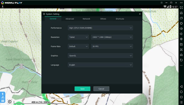
Locus Map not only allows you to use the excellent OpenAndroMaps, it works with many other map types too, online and offline. Locus Map will run successfully in the MEmu emulator on Windows 10. I can't test earlier Windows versions. Once the emulator is installed and running then everything behaves as if using a phone. First have a play with MEmu to find the best display settings for your computer screen. Click MEmu's gear cog icon to enter system settings and find 'Resolution' under the General tab. 'Tablet 1920 x 1080' is perfect for a standard 16x9 screen.
Then Locus Map can be downloaded from the Google Play store built in to the emulator. Follow the instructions for getting started with Android smartphones. A touch screen is not required. A mouse works fine for using Locus Map in MEmu.
It will use mapsforge maps by OpenAndroMaps, common raster map files and view online maps. The interface is aimed at mobile devices but it works well enough on a desktop. See more on Cartograph in Getting started with iPhones as using Cartograph should be much the same on any platform.
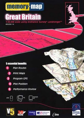
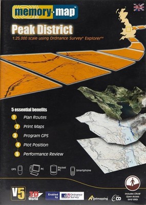
Ordnance Survey maps Government funded and unrivalled for quality the digital OS maps are usually expensive. The whole UK can be bought for offline use and there are subscription services which allow areas to be downloaded as required. I think the subscription model is more appropriate for hill walkers where it's easy to predict what area will be needed. Any supplied map files are usually proprietary and not designed for sharing.
For many years Memory Map has been like a digital arm of the Ordnance Survey for ordinary consumers (although they are a separate company). Although the OS now have a map app, Memory Map probably still have the best suite of OS map products. They have a good app (iOS and Android) and good desktop software (Windows only). OS mapping may be bought in bite-size chunks or the whole UK. Current cost is over £300 for maps of the UK at 1:50k and 1:25k. The UK is also available as 6 smaller regions. These products make it easy to put large areas of the UK on a smartphone or computer. A good thing.
Smaller areas are downloaded via the 'Digital Map Store' from within the Memory Map app and desktop software. Memory Map can also provide CAA VFR air charts, marine charts and the French IGN mapping.
A new licensing system was introduced with the Digital Map Store in 2010 and the newer maps are encrypted (.qc3 file suffix). However between about 2005 and 2010 'V5' OS maps were not encrypted (.qct suffix) . Although a proprietary format any app that understands the format can use the maps. These maps are more flexible and may be successfully shared. eg The full version of the Alpine Quest app works with V5 .qct maps. The new Memory Map app and desktop software will also use the older .qct files with a one off payment of £15 for a 'Classic Maps Compatibility license'. eBay and Amazon still provide a source of V5 map CDs and DVDs. If you're lucky you might pick up a cheap DVD containing OS mapping for the whole UK. Copying .qct files from a CD or DVD to Alpine Quest's offline map folder will make them available in the app. The V5 desktop software supplied with the V5 discs runs fine on Windows 10. It will export custom selections as .qct files which can then be used by anybody with Alpine Quest or Memory Map. The older V5 software also has the benefit of working with V5 .qct files without needing to buy a 'Classic Maps Compatibility license'.
If browsing a V5 Memory Map disc you'll see three files associates with each map. The file suffixes are .qct, .mmi and .qed. .qct: This is the geo-referenced map image and the only file that Alpine Quest or Memory Map needs to accurately show your position on the map. .qed: This file only contains elevation data. If present Memory Map software can 3D warp the map, provide spot heights and generate height profiles of a route etc. These files are not necessary for navigation and the app will work just fine without them. Alpine Quest does not use these files. .mmi: This file is just an index of place names and enables Memory Map to search for 'Keswick' or 'Windermere' and show it on the map. Again, not necessary for navigation and the app will work without them. Alpine Quest doesn't use them.
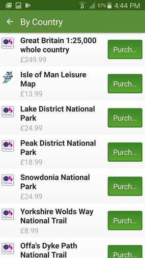
It may pay to look around. At the moment the free demo version of the BackCountry Navigator smartphone app will download 25k and 50k OS maps for free! Supplied by Bing Maps, the max area that may be downloaded at a time is about 25km x 35km. I'd be surprised if this continued forever. The Viewranger app is a good one and has an excellent in-app shop. Whole country and National Park OS downloads are available as well as a subscription service. £20 a year gives full access to the OS maps and areas may be downloaded as required.
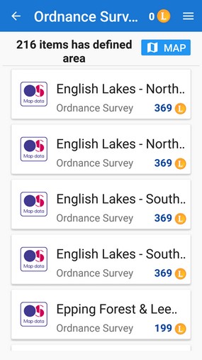
Locus Map's in-app shop offers OS map sheets individually. A single Locus Store download includes both 25k and 50k maps. The Ordnance Survey's 'OS Maps' app has a subscription service (£20 a year) but the app is basic. More modern Garmins can use OS maps. Garmin call them TOPO Pro maps and supply them on a microSD card. £500 is needed for the UK at 25k and 50k. Ouch. Don't be tempted to pay for the 'Topo Light' maps. They will be OpenStreetMap based and something similar can be obtained for free from TalkyToaster, AlternativasLibres and others. Garmin's desktop software Basecamp has BirdsEye Select which allows the purchase of custom selections. These can be transferred to the hand held units. Apart from Memory Map there are a few other desktop applications that offer OS maps. Mapyx Quo, Anquet and Tracklogs. Anquet provide a MAC OS program.
Links
|
|
|---|---|---|


![]() Book and mountain bike icons made by Freepik from www.flaticon.com is licensed by CC BY 3.0
Book and mountain bike icons made by Freepik from www.flaticon.com is licensed by CC BY 3.0