W - NW |
Clough Head |
| Status : | OK | ||
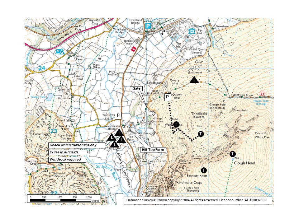
| IMPORTANT - Restrictions on use | BOTTOM LANDING FIELDS & FEES - THIS IS NOT OPTIONAL: It is £2 per pilot for landing in the Hill Top Farm fields (for which fields see photo 1 and map; leave £s on windowsill at the farm see photo 2). - If you intend to use a field, please pay BEFORE you fly - otherwise TOO MANY PILOTS FORGET and this causes difficult issues for the club. - We have permission to land in the right hand field closest to the road (looking from the hill) PROVIDED it is free of sheep or long grass (hay). IF AT ALL UNCERTAIN ask which field at Hill Top Farm. Then, if possible, put a windsock in the nominated field and message the info on the TELEGRAM GROUP/s (to save further disturbing Mr & Mrs Bell). - DURING LAMBING OR HAY-MAKING YOU MAY FIND ALL THE LANDING FIELDS ARE CLOSED. If so then land on the fellside or don't fly - the best rock free fellside landing is north of Threlkeld Knotts next to the track (see map and landing notes). - DO NOT land in any other valley fields anywhere near the CLOUGH site - except in emergency. PARKING: - If the fields are not too wet, on request at Hilltop Farm and payment of £1 per car, you may be allowed to park in one of their fields. - Do not cause parking obstruction on the main road or on any tracks, or at gates or entrances. - Locals have specifically requested that we are careful where we park - this is a busy area and there have been serious problems with inconsiderate parking. LANDING AT GRASMERE: If you fly down the ridge and land here, note this guide's advice in the 'landing areas' section under the 'Flying' tab. It is important we comply. |
||
| Last Updated : | 29/03/2026 at 02:13 by Rick Livingstone | ||
| Last Reviewed : | 28/04/2023 by | ||
| Wind : | W - NW | ||
| Nil Wind : | Yes | ||
| Grid Ref : | NY328231 | Height (AMSL) : | 1470' / 448m |
| Site Code : | 17.06 | Top to Bottom : | 1017' / 310m |
Location
N Lakes - 5 kms ESE of Keswick
Details
A large impressive site which is good in light wind or thermic conditions. The site gives easy access to the chain of high ridges running south towards Helvellyn.
Site Officer
:
Postcode for Sat Nav Systems (read the Health Warning!)
CA12 4TS - This is the closest mail delivery point to the flying site and is positioned at:
Bram Cragg.The postcode centre is about 2km south of the parking area along the B5322
Getting There
From Penrith or Keswick, take the A66(T) and turn off onto the B5322 at Threlkeld. If travelling from the Ambleside / Grasmere direction take the A591 north and turn off onto the B5322 at St. John's in the Vale. The access track to the fellside begins at grid reference NY 316 231 (signposted 'Old Coach Road').
The best parking is if Hilltop Farm has availability, although there is limited parking around the start of the track - DO NOT CAUSE any obstructions! See restrictions on front page of guide for details.
If you have a 4x4 (or are brave!) you can drive up the track passing through two gates (shut after use) to the open fell. The car parking area is 80m / 250' higher in a flat quarry (hidden from view) on the right of the steep and loose track, the track can have places in poor condition.
Getting to takeoff
Make for a suitable take off area on Threlkeld Knots that rise above the quarry to the SE. The path is vague to start with but you will soon find a more definite track that can be followed to the take off area. In light wind / nil wind conditions it may be necessary to go right to the summit of Clough Head itself. This is a stiff 1180'/360m of ascent from the quarry.
Permission to use site
Hill Top Farm main access and three other local farms.
Hazards
Pilots should be reasonably experienced to cope with certain conditions found at and around the site, especially during the spring months.
Consider the wind speed due to compression over the shallow summit slopes. Keep well forward and crab north if getting blown back.
Beware of scratching too close to the cliffs in thermic conditions or if the wind has a little south in it.
St John's in the Vale valley has a lot of RAF activity, so it is advised to CANP this site before flying.
Also see 'Landing Area' note re Grasmere.
Take Off
The take off area is grassy and covers a large area. Its a matter of picking the best area given the previaling wind direction. Recommended practise is to make a few beats in the Threkeld Knotts area before making for the Wanthwaite Crags area. The scoop to the south of take off can be a bit sinky so its best to get a bit of height before making the traverse. You can usually get good lift over Wanthwaite but be aware that this area is pretty unforgiving. If the wind is south of west you may need to be careful here.
Landing Areas
See landing instructions in the restrictions section.
A windsock is very useful in the bottom landing field - not least to show other pilots the correct field for the day. It can be lifty over the landing fields: prepare to be patient - the fields are separated by dry stone walls which are very unforgiving.
Care when top & especially side landing on the fellside due to hidden rocks - the best rock free place is north of Threlkeld Knotts next to the track (see map).
In fresh winds there can be a significant venturi effect to the north of Threlkeld Knotts, so if landing here be ready to keep forward.
LANDING AT GRASMERE:
- STAY SAFE: On any good day military fast jets and transport aircraft may fly along the middle of the valley and through a pinchpoint over Grasmere at ~200ft, making this area extremely dangerous, plus they cannot turn left or right to bail out. To deconflict, keep out of the middle of the valley below ridge height and lose height over the East side of the valley staying close to the slope and traversing to the landing field late.
- Your first choice of landing field should be the Grasmere Showground, ideally the large central section in front of the pavilion. When landing you must keep well clear of any caravans/motorhomes/tents/etc by using the central or southerly areas of the showground, and never climb walls or fences.This is vital to retain good relations with the Sports Committee, YOU WILL PUT OUR ACCESS AT RISK IF ANY OF THIS IS IGNORED. The showground is large and easy to spot from the air, it is SE of Grasmere village and next to the A591 main road.
- If the showground has an obvious major event in progress (e.g. the Fred Whitton cycle race) or is otherwise full of campers, then you must land elsewhere. The alternatives, in order of preference, are the field immediately north of the showground (which has a public right of way through it) or the field immediately across the road south of the showground (which maybe be unsuitable on the day as it can be used for event car parking).
- Only land elsewhere if there is an event in progress and the alternative fields are either crammed with livestock, has ewes with lambs in it, is in hay or full of cars. And then only do so with great care, valley land is precious in Grasmere and the farmers rely on the valley to make their living; please be respectful of this. Also there are many overhead wire hazards that are difficult to see from the air, especially near the A591 and the built up area of Grasmere village.
- In a dire emergency, your personal safety takes precedence over the above.
Flying
The site gives excellent XC potential with routes to the south along the Helvellyn Range and on towards Ambleside and Kendal and routes over the high fells heading south east towards the Howgills and the Yorkshire Dales. In nil wind or light wind conditions the site offers the potential for some great triangle flights. The site is often considered an 'afternoon site' after the sun has warmed up the cliffs. Although the sea breeze can occasionally reach Clough Head, it doesn't present any particular hazard, but (as usual) kills the thermals. Avoid any ground skimming over the lower slopes especially during the lambing period (Feb - May). Clough Head is a valued hang gliding site which poses few problems but there are limited landing opportunities between Helvellyn and Seat Sandal (forest and water). Do not get too low.
XC potential
The site gives excellent XC potential with routes to the south along the Helvellyn Range and on towards Ambleside and Kendal and routes over the high fells heading south east towards the Howgills and the Yorkshire Dales. In nil wind or light wind conditions the site offers the potential for some great triangle flights.
See notes on site status
Photos
Click on the photo for a full size image.
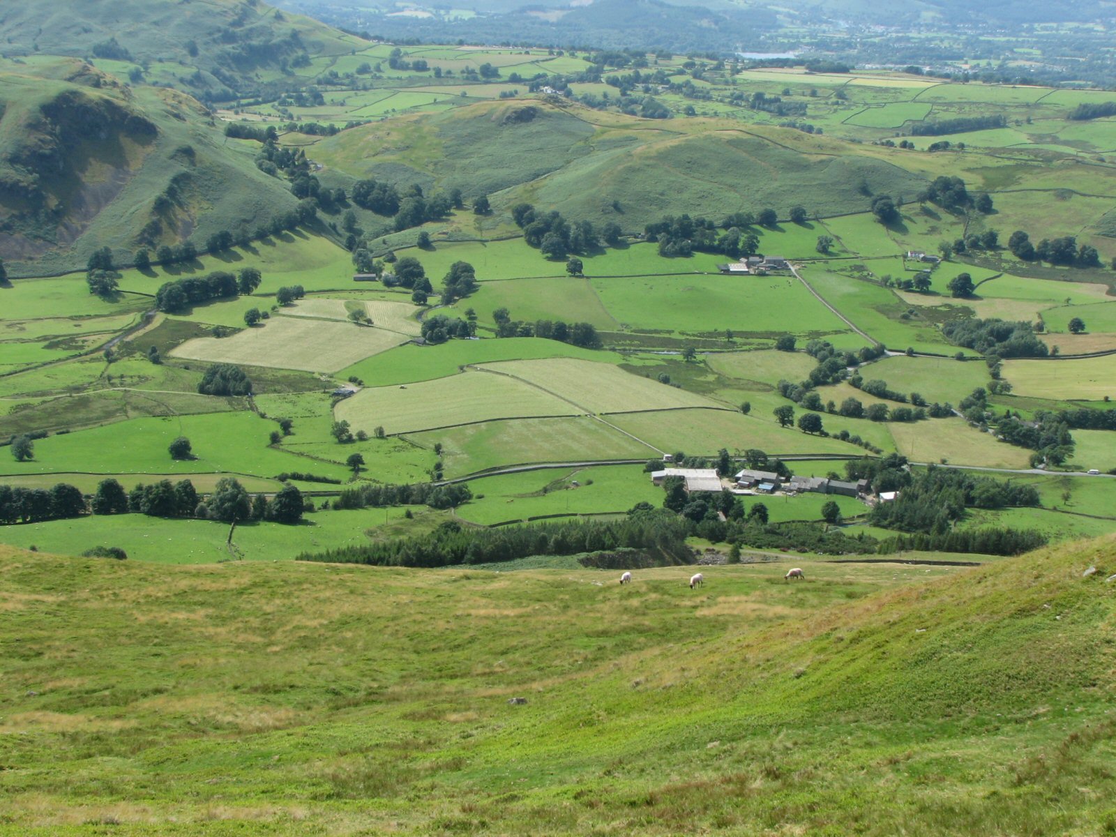
| PHOTO 1 The alternative to landing on the fell are the 4 fiields in the valley in the centre of the photo as the quadrants of a cross. This photo was taken in July when the grass was being cut. See site guide main page for details and landing fees info. |
 |
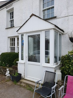
| PHOTO 2 if you intend to land in the Hilltop Farm landing field, BEFORE FLYING leave your £2 landing fee on the window sill of this porch at the farm. See site guide main page for details and landing fees info. |
 |
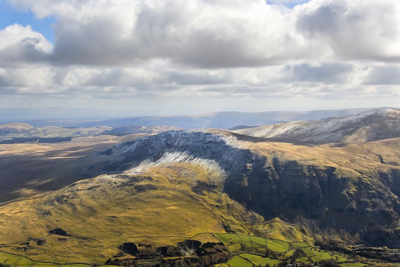
| An aerial view of Clough Head looking SE. The car parking quarry can be seen in the lower left of the picture with the track to take off leading diagonally right up the fell side. Take off is generally in the area around the track just before the snow line. Photo reproduced with the permission of the copyright owner, Andrew McMahon. More pictures can be found on his web site. |
 |
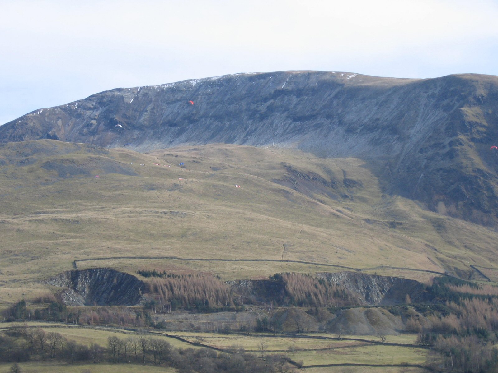
| Looking up to Clough Head from down in the valley. Take off can seen in the centre, the 3 lower gliders are below takeoff |
 |
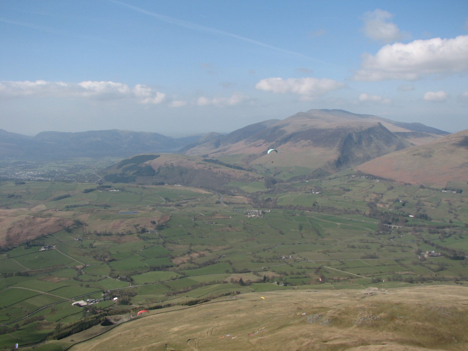
| Looking down on the site from a glider. Takeoff is at the bottom of the picture; the car park quarry is over on the right and the landing area to the right of the car park. |
 |
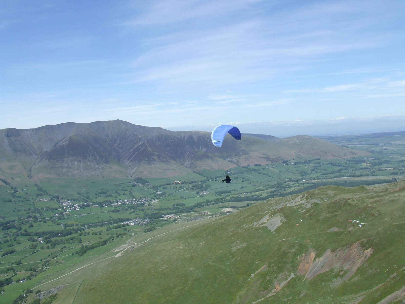
| Looking further round to the east with Blencathra in the background. The takeoff areas are marked by gliders. Photo by Dave Horne |
 |
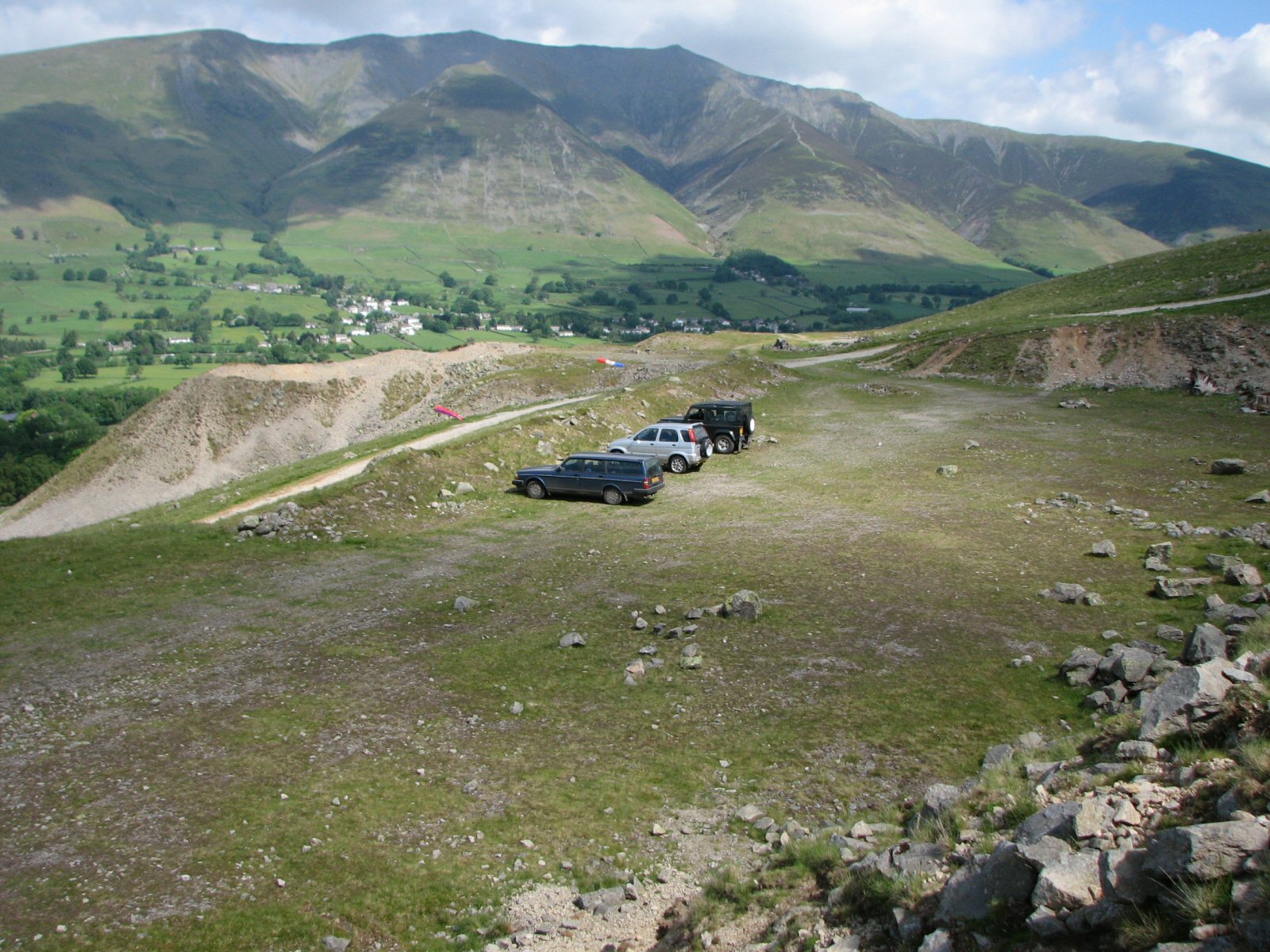
| The upper car park at Clough Head. The entrance is on the right of the track just after the steep uphill section. |
 |
Local Information - Pubs/Food etc
Nearest pubs to the site - for post flying debriefing only! You may find details of other facilities here
No pub details are available for this site. Send your recommendations to the webmaster.
This page shows records for this site. Some of the older records are not very detailed. More recent records may have an igc file available You can right click and download this to your PC. You can then use IGC Flight replay to view the flight.
| Paragliding |
| Declared Out and Return | |
| Distance : | 32.7km |
| Date : | 07/08/2009 |
| Pilot : | Mike Cavanagh |
| Notes : | |
| FAI Triangle | |
| Distance : | 34.3km |
| Date : | 25/05/2013 |
| Pilot : | Steve Etherington |
| Notes : | |
| IGC File : | Right click to download |
| Open Distance XC | |
| Distance : | 140.8km |
| Date : | 21/04/2010 |
| Pilot : | Burkitt Rudd |
| Notes : | Landed Aberford - between Leeds and Selby - 152.2km via 3 turn-points. Click here for more details. |
| Out and Return | |
| Distance : | 35.8km |
| Date : | 31/08/2014 |
| Pilot : | Rick Livingstone |
| Notes : | A clever use of turn points to push the out and return distance a little further |
| IGC File : | Right click to download |
| Hang Gliding |
| Open Distance XC | |
| Distance : | 93.3km |
| Max Height : | 5000ft |
| Date : | Unknown |
| Pilot : | Ian Ferguson |
| Notes : | Ed Cleasby provided the much needed retrieve! |
Data Resources
Follow the links to see the site in Google Earth and Google Street view. To access the former, you will need to have Google Earth installed on your PC. You can also upload your flights to GE - use GPS Dump (Links Page) to convert a variety of GPS file formats to a GE kml file.
| Link | Resource Type | Notes |
|---|---|---|
| Google Earth - Car Park | ||
| Google Earth - Car Park 2 | ||
| Google Earth - Sample Flight 1 | Kitt Rudd's flight to Appletreewick near Skipton in the Yorkshire Dales - March 2008 | |
| Google Earth - Sample Flight 2 | Ridge running for beginners. Ian Henderson's first trip down the ridge to Grasmere. It was the thermal over the quarry that finally gave me the confidence to go. | |
| Google Earth - Take Off | ||
| Google Street View - Parking | The beginning of the track up to Clough Head. The track is deteriorating, only go past the gateif you have a 4x4 or you don't care about your car. Please be considerate when parking your car and allow room for people in the bungalow. |
Clough Head Map |
Legend |