SSW - S |
Whinfell |
| Status : | OK | ||
| IMPORTANT - Restrictions on use | Anyone flying for commercial gain must seek prior approval (schools, tandems ect). |
||
| Last Updated : | 12/11/2025 at 18:07 by Jacob Aubrey | ||
| Wind : | SSW - S | ||
| Nil Wind : | No | ||
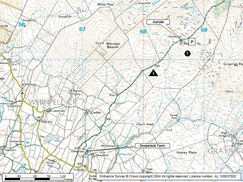
| Grid Ref : | SD588999 | Height (AMSL) : | 1427' / 435m |
| Site Code : | 17.08 | Top to Bottom : | 492' / 150m |
Location
SE Lakes - E of Kendal
Details
An excellent site, quite shallow but it works well. One of the few true southerlies in the district. Good top landing but growth in the number of masts may restrict things a little.
No need to ask permission but please close all gates if opened and respect the farmers instructions.
Site Officer
Jacob Aubrey : 07505 265668
Postcode for Sat Nav Systems (read the Health Warning!)
LA8 9EH - This is the closest mail delivery point to the flying site and is positioned at:
Tarnside. This building lies about 100m east of the turn off for the track up Whinfell.
Getting There
A685 north from Kendal to Grayrigg. Turn left at Church and follow a minor road for 2.8km to Low Deep Slack (farm on right across a field - ask permission). Contiunue along road for further 800m to a gate on the right. This is the start of the track.
Getting to takeoff
Drive the tarred fell road to masts ....no walking required. (On occasions the gate may be locked .... check at Low Deep Slack).
Permission to use site
Low Deep Slack Farm.
Additional Safety Notes
Masts and a power line up the front, left of the hill, otherwise OK
Paragliding
The take off area is quite shallow and has a power line running through the face of the hill. Whinfell Beacon itself is a no go area for take off but can be overflown but not scratched!
Hang Gliding
Excellent. A very effective site with a tarred road to the top. The site can be affected by sea breeze.
XC potential
Quite good ....fair thermals.
No photos available for this site. Good quality photos of CSC sites always required.
Local Information - Pubs/Food etc
Nearest pubs to the site - for post flying debriefing only! You may find details of other facilities here
No pub details are available for this site. Send your recommendations to the webmaster.
This page shows records for this site. Some of the older records are not very detailed. More recent records may have an igc file available You can right click and download this to your PC. You can then use IGC Flight replay to view the flight.
| Paragliding |
| Flight to Goal | |
| Distance : | 60.6km |
| Max Height : | 4980ft |
| Date : | 13/04/2026 |
| Pilot : | Andy Austin/Pete Morris |
| Notes : | Flight to goal, Brampton train station, duration 2hr 20mins, max speed 80 km/h, Average speed 29.1 km/h. A few rain cells to Navigate! |
| Hang Gliding |
| Open Distance XC | |
| Distance : | 43.3km |
| Max Height : | 3400ft |
| Date : | Unknown |
| Pilot : | Unknown |
Data Resources
Follow the links to see the site in Google Earth and Google Street view. To access the former, you will need to have Google Earth installed on your PC. You can also upload your flights to GE - use GPS Dump (Links Page) to convert a variety of GPS file formats to a GE kml file.
| Link | Resource Type | Notes |
|---|---|---|
| Google Street View - Parking | The entrance to the track up the fell |
Whinfell Map |
Legend |