SSW - W |
Bewaldeth |
| Status : | OK | ||
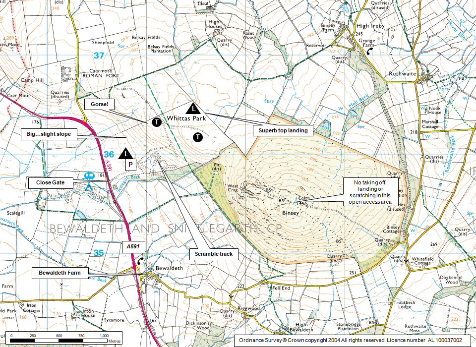
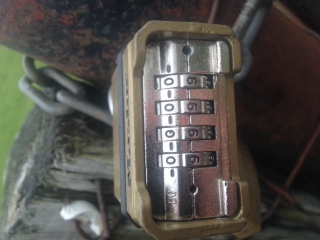
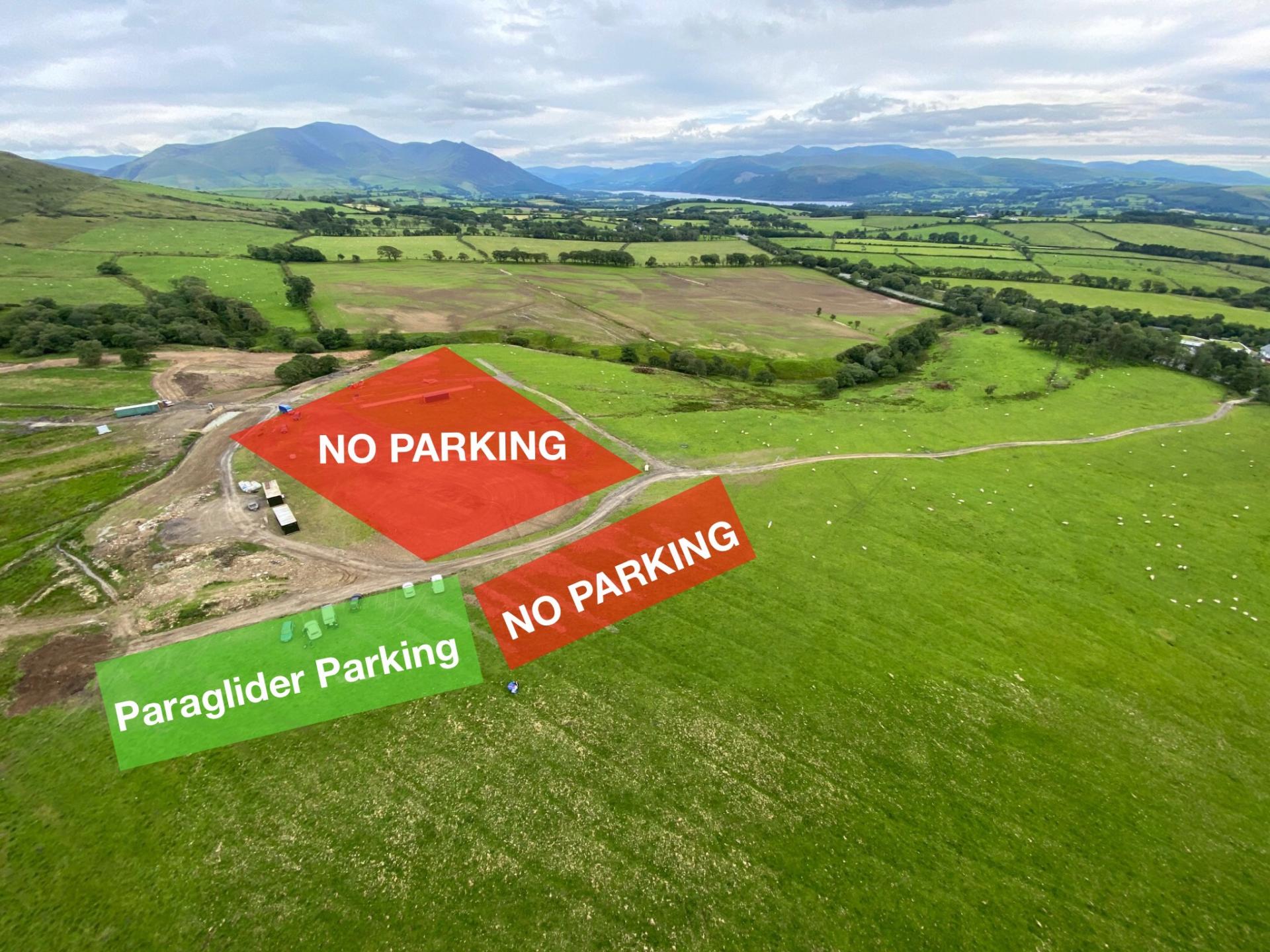
| IMPORTANT - Restrictions on use | SITE ACCESS: - Permission to fly no longer required BUT there is still a £1 site flying fee (per pilot per day). Put your money in the CSC honesty box located at the main accesss gate (see photo 1). - The site entrance gate may have a combination lock (see photo 2, note code position); get the code from Gordie Oliver (07830 281986), or the site officer or the Sick and the Wrong. Please keep the code confidential. Otherwise park in the huge lay-by across the main road (A591) from the site entrance and walk up. PARKING: The MotoX track is being revamped, they have re-seeded the ground to the right (south) of the large rock at the entrance of their area. They have requested that we park on the left (north) of the track, closer to the hill (see photos 2 & 3). TRAINING: Note that this is an essential site for training and schools using the site have priority. While there may be scope for other pilots to fly, numbers may be limited. If you are a qualified pilot, please allow space and priority for training. BINSEY: This is the large hill SE of Whittas Park (see map below). It is an active grouse moor with a gamekeeper and owners who actively oppose wildlife disturbance...... Please DO NOT LAND OR TAKE OFF FROM anywhere in the whole fenced Binsey area, unless an emergency. NESTING BIRDS & AERO MODELLERS: Avoid the NW end of the site during the nesting season and if model aircraft flyers are using it. DOGS: No dogs allowed on the flying site without permission. |
||
| Last Updated : | 29/03/2026 at 02:10 by Rick Livingstone | ||
| Wind : | SSW - W | ||
| Nil Wind : | No | ||
| Grid Ref : | NY211362 | Height (AMSL) : | 980' / 299m |
| Site Code : | 17.014 | Top to Bottom : | 240' / 73m |
Location
N Lakes - W of Skiddaw
Details
A small site which works better than its size would suggest. This site is very user-friendly, with a flat top and large open landing area. Hence it is a key training site in the area. Fair conditions allow the crossing to Binsey to be made so increasing the scope of the site.
Suitable for novice CPs as long as they don't stray from the site and they respect both windy days and strongly thermic days.
This is Jocky Sanderson's summary of the site:
"Bewaldeth is one of the classic jewels in the CSC’s crown. It was where the first hang gliders flew and CSC pilots owe their thanks to the McTear family for their continued kindness and support over the years and long may that continue. Many of us learnt to fly at Bewaldeth and others will continue to do so given good co-operation & communication between the pilots, clubs and schools involved in managing the site and by respecting the farmer's wishes."
Site Officer
:
Postcode for Sat Nav Systems (read the Health Warning!)
CA13 9SU - This is the closest mail delivery point to the flying site and is positioned at:
Centre of Bewaldeth village, about 1 mile south of the access road to the site.
Getting There
The site is visible from the A591 just North of the village of Bewaldeth. Coming from Keswick, look for a campsite entrance on the left, just after this turn right through a gate into a field.
Parking:
The site entrance gate may have a combination lock (see photo 2); get the code from Gordie Oliver (07830 281986), or the site officer or from the Sick and the Wrong. Please keep the code confidential. Otherwise park in the lay-by across the main road (A591) from the entrance and walk up.
PARKING: The MotoX track is being revamped and they have re-seeded the ground to the right (south) of the large rock at the entrance of their area. They have requested that we park on the left (north) of the track, closer to the hill (see photos 2 & 3).
Getting to takeoff
A short walk-up of about 10 minutes. Avoid the direct route up the gap in the gorse bushes. Walk up to the right.
Permission to use site
The McTear family, Bewaldeth Farm.
Hazards
When the wind is off to the West, it can become turbulent, especially over the gully to the right of takeoff.
Suitable for novice CPs as long as they don't stray from the site and they respect both windy days and strongly thermic days.
Take Off
Please ensure you comply with the site restrictions!
Avoid the direct route to take off up the gap in the gorse bushes, instead please walk up to the right.
Easy grassy take off area.
Landing Areas
The bottom landing is uneven with a slight downslope.
Excellent big flat top landing area behind take off.
Flying
A very useful site which can sometimes be flown when poor conditions, such as low cloudbase or stronger winds at higher altitudes, put the bigger sites out of bounds.
When schools are using the site, experienced pilots should take off to one side or the other of the main take off area, and give student pilots plenty of room.
In stronger conditions it is possible to take off at the base of the slope and fly up, but beware the gorse bushes ;-)
During the nesting season (end March - end July) avoid the NW end of the site (past the beck on the north end of the ridge) as there are nesting curlews; if possible don't land, walk or scratch there so as to give the birds plenty of space.
XC potential
The site is a good thermal producer making it easy to get away over flat ground downwind.The area has minimal restrictive airspace downwind. Possibly underestimated potential, as pilots are likely to use other sites on the best days. Hexham is the current record set by Pat Holmes in the 90's, a flight where he never got above 1,500ft AGL!
Photos
Click on the photo for a full size image.
| Photo 1. Honesty box for site fees, located at the main access gate (£1 per pilot per day) |
 |
| Photo 2. Combination padlock. Set the code in the same position as the line of zeros. |
 |
| Photo 3. PARKING: The MotoX track have re-seeded the ground to the right (south) of the large rock at the entrance of their area. They have requested that we park on the left (north) of the track, closer to the hill. |
 |
| Photo 4. Close up of parking area. |
 |
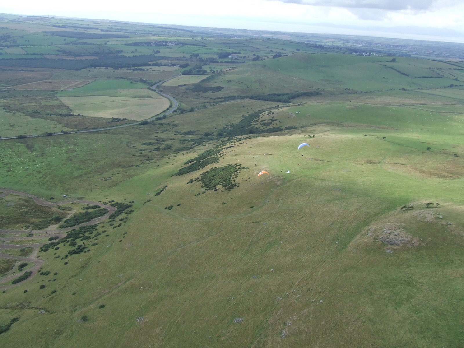
| Photo 5. A good overall view of Bewaldeth from the air. Take off is marked by the gliders, landing is by the car. Photo by Dave Horne |
 |
| Photo 6. Looking back to take off from the north, Binsey in the background. Photo by Paul Gannon |
 |
Local Information - Pubs/Food etc
Nearest pubs to the site - for post flying debriefing only! You may find details of other facilities here
| The Sun Inn, Bassenthwaite | |
| Grid Reference : | NY231323 |
| Distance from Site : | 3.0 miles |
| Notes : | Gordie Oliver's local |
| Click here to go to the web site | |
| Click here to see the place in Google Street View |
This page shows records for this site. Some of the older records are not very detailed. More recent records may have an igc file available You can right click and download this to your PC. You can then use IGC Flight replay to view the flight.
| Paragliding |
| Open Distance XC | |
| Distance : | 74.2km |
| Date : | 02/06/1996 |
| Pilot : | Patrick Holmes |
| Out and Return | |
| Distance : | 29.0km |
| Date : | 23/04/2008 |
| Pilot : | Steve Etherington |
| Notes : | TO 16.45 Flew to Jenkin Hill and back Glider Niviuk Icepeak XP |
| Hang Gliding |
| Open Distance XC | |
| Distance : | 35.4km |
| Max Height : | 4100ft |
| Date : | Unknown |
| Pilot : | Unknown |
Data Resources
Follow the links to see the site in Google Earth and Google Street view. To access the former, you will need to have Google Earth installed on your PC. You can also upload your flights to GE - use GPS Dump (Links Page) to convert a variety of GPS file formats to a GE kml file.
| Link | Resource Type | Notes |
|---|---|---|
| Google Earth - Car Park | ||
| Google Street View - Parking | Up the track on the right |
Bewaldeth Map |
Legend |