SW - WNW |
Buttermere Moss |
| Status : | OK | ||
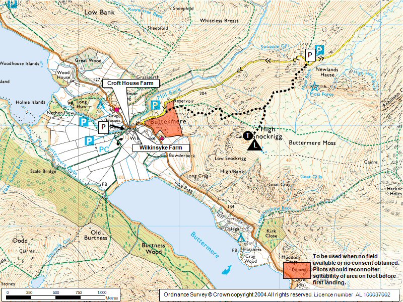
| IMPORTANT - Restrictions on use | LANDING: If you intend to land in fields around Buttermere Village: 1. Unless you already know which field we have been granted permission to use, then PLEASE agree one with Mr Kyle at Syke Farm/Café/Ice Cream Shop (NY176170) Phone: 017687 70278 (usually this is for the long narrow field behind and West of the Buttermere Court Hotel - was the Fish Inn). 2. If no permission for a landing field can be obtained then you will be restricted to landing at the foot of the fell (as shaded in orange on the site guide map and see photo). This is rougher ground than a field, but should be no issue for competent pilots, suggest pilots should reconnoiter the area on foot before landing here for the first time. 3. If you land elsewhere you may be accosted by a member of the Beard family, who have asked that the club discourages pilots from landing in their fields. Try not to land in a field with livestock. Be polite, don't argue! 4. Remember your safety takes priority - in difficulties or an emergency situation land where necessary. |
||
| Last Updated : | 29/03/2026 at 02:21 by Rick Livingstone | ||
| Wind : | SW - WNW | ||
| Nil Wind : | No | ||
| Grid Ref : | NY187169 | Height (AMSL) : | 1725' / 526m |
| Site Code : | none | Top to Bottom : | 1390' / 424m |
Location
NW Lakes - Buttermere
Details
This site has lovely grassy flat-topped take off areas and big fields to land in (as long as you've asked permission).
The site makes for a very pleasant top to bottom if you haven't flown for a while.
Best flown in a true westerly.
Suitable for novice CPs as long as they don't stray from the site and they respect both windy days and strongly thermic days.
Excellent XC potential for the experienced.
Site Officer
:
Postcode for Sat Nav Systems (read the Health Warning!)
CA13 9XA - This is the closest mail delivery point to the flying site and is positioned at:
Buttermere Youth Hostel. Postcode point is 100 metres SE of youth hostel along B5289
Getting There
If heading from Keswick, drive west into Braithwaite. There, take the second left onto a narrow lane that eventually winds up Newlands Pass. At the top of this pass you normally park (NY193176) to walk up (see below). If you have 2 cars leave one in Buttermere Village and drive back up. If you only have one car, leave it in the village and walk east from NY179172.
Getting to takeoff
From the top car park, scramble up the steep path leading south. When the path levels out follow it SW to High Snockrigg and choose the best wind-facing slope (from top car park it is an, initially strenuous, 20 minutes walk).
Permission to use site
Take off is from the open fell land.
Valley landings thanks to:
Mr Kyle, Syke Farm/Café/Ice Cream Shop and Mr & Mrs Temple, Cragg House Farm.
Hazards
Keep an eye on the state of the lakes for an idea of how windy it is down in the valley, and for signs of the sea breeze approaching. On a thermic day the sea breeze may come in from the NW early afternoon, the site will continue working although with reduced lift. Care should be taken if flying in a SW moderate wind due to the big fells across the valley that will cause the conditions to become turbulent.
Suitable for novice CPs as long as they don't stray from the site and they respect both windy days and strongly thermic days.
If going XC: Before going deep into, or high over, the big mountains make sure you know what you're doing & where you are going. Otherwise fly in radio contact with a competent guide and ensure you don't lose height close downwind of summits or behind spurs thereby dropping into rotor and severe turbulence. If it's a windy day (over 10mph?) think twice before making committing moves! NOVICES BEWARE!!!
Take Off
A good site under the right conditions but can become very turbulent in the wrong conditions (see Hazard Notes).
This site has lovely grassy flat-topped take off and top landing areas.
The site makes for a very pleasant top to bottom if you haven't flown for a while.
Landing Areas
Remember your safety takes priority - in difficulties or an emergency situation land where necessary.
Excellent top landing area behind take off.
Large bottom landings fields in the valley PROVIDED you have permission! Please read restrictions section for more info.
If no permission for a landing field can be obtained then you will be restricted to landing at the foot of the fell (as shaded in orange on the site guide map and see photo). This is rougher ground than a field, but should be no issue for competent pilots. Pilots should reconnoiter suitability of area on foot before first landing
In light winds and with care competent pilots can also land at the summit of Newlands Pass just north or west of the car park (beware wind venturi through the gap).
Flying
Best flown in a true westerly.
The site still flies well after the sea breeze comes in from the NW but has reduced lift.
XC potential
Buttermere Moss has excellent XC potential in amongst big mountains! The opportunities for exploring up and down the Lorton & Buttermere valleys and beyond are superb.
An out & return flight to Robinson, the big mountain 2kms to the east, is a potential XC training task.
Further afield, for experienced XC pilots, flights to Keswick by various routes are frequently achieved and it is possible to connect via Borrowdale across Thirmere and then up or down the Helvelyn range, with the rest of the eastern Lake District at your feet!
Photos
Click on the photo for a full size image.
| General view of parking, ascent route and take off area. |
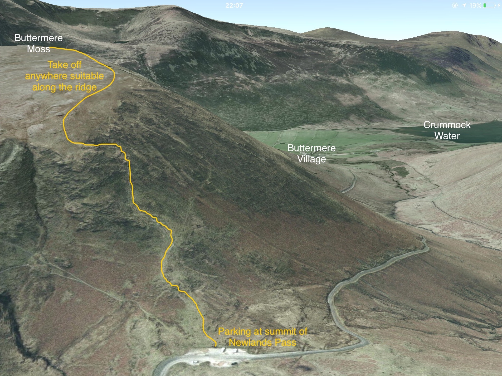 |
| One of the take off areas. Essentially the top is a small plateau; choose the best take off spot depending on the wind direction. |
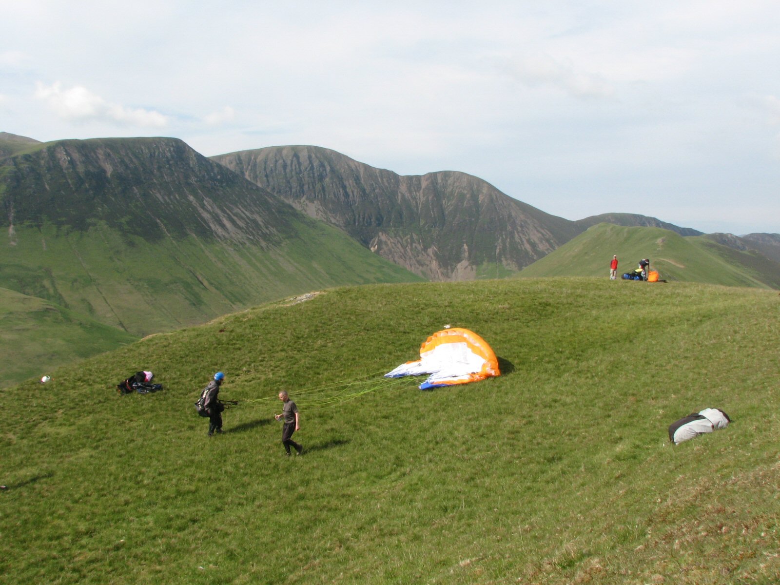 |
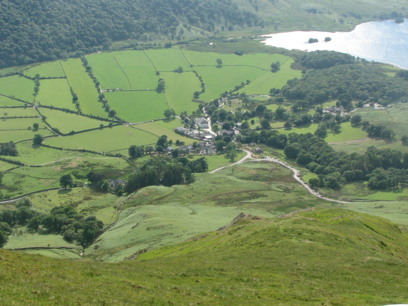
| Looking down to the landing areas from take off. The rough ground area is between the 2 roads to the left of the parked cars. The other fields are behind the Fish Hotel, the prominent white building in the vee. |
 |
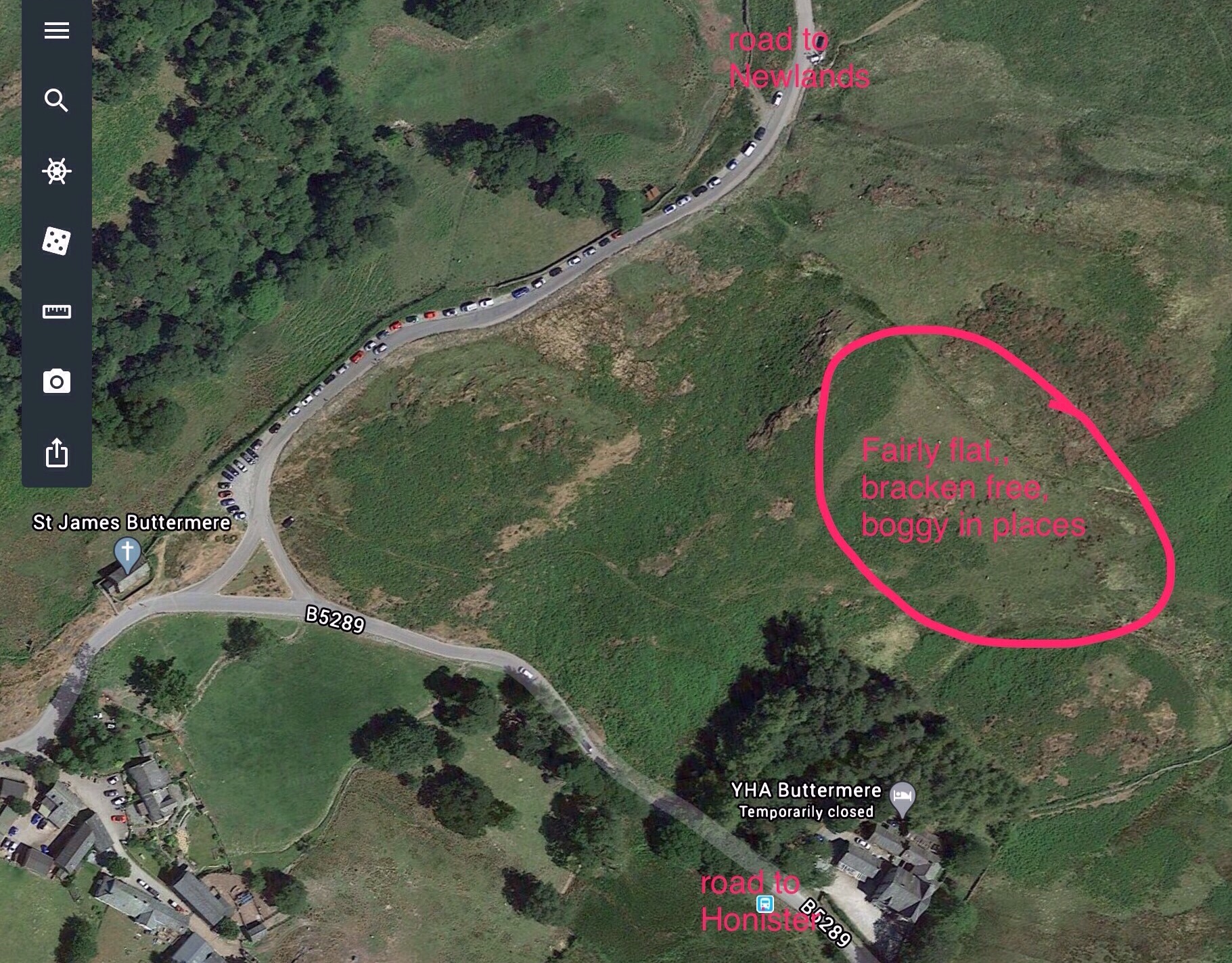
| Aerial view of landing area at the foot of the fell (as shaded in orange on the site guide map). This is rougher ground than a field, but should be no issue for competent pilots. Pilots should reconnoiter suitability of area on foot before first landing |
 |
Local Information - Pubs/Food etc
Nearest pubs to the site - for post flying debriefing only! You may find details of other facilities here
| Two pubs: The Fish & The Bridge | |
| Grid Reference : | NY175170 |
| Distance from Site : | 2.0 miles |
| Notes : | Both pubs are in Buttermere Village. Both serve food. |
| Click here to see the place in Google Street View |
This page shows records for this site. Some of the older records are not very detailed. More recent records may have an igc file available You can right click and download this to your PC. You can then use IGC Flight replay to view the flight.
| Paragliding |
| Turnpoint Flight | |
| Distance : | 50.8km |
| Date : | 22/05/2010 |
| Pilot : | Phil Colbert |
| Notes : | See http://www.xcleague.com/xc/flights/20101005.html for details |
| IGC File : | Right click to download |
| Hang Gliding |
No hang gliding records available for this site
Data Resources
Follow the links to see the site in Google Earth and Google Street view. To access the former, you will need to have Google Earth installed on your PC. You can also upload your flights to GE - use GPS Dump (Links Page) to convert a variety of GPS file formats to a GE kml file.
| Link | Resource Type | Notes |
|---|---|---|
| Google Earth - Car Park | ||
| Google Earth - Car Park 2 | ||
| Google Earth - Take Off | ||
| Google Street View - Parking | Newlands Hause parking. The track to take off is the (steep!) one on the right going directly up the nose. |
Buttermere Moss Map |
Legend |