S - SSE |
Blease Fell |
| Status : | OK | ||
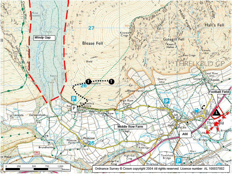
| IMPORTANT - Restrictions on use | LANDING FIELDS - Below the fell wall preferably use the 'MAIN'/ Lower Landing Field (next to A66 Car Park) and use the 'SECONDARY'/ Upper Landing Field (Blease Road) only if no other option. Both fields are fully described in the Flying Tab 'Landing Areas' section, the site map and photos 1 & 2. DO NOT land in any other fields. - DO NOT MIX IT UP with the school games field in the centre of the village. - Visiting pilots ignoring the site guide causes problems, this may result in a CSC MEMBERS ONLY site. PARKING NEXT TO 'MAIN'/ LOWER LANDING FIELD The car park is now PAY & DISPLAY (£3 for all day, no overnighting) |
||
| Last Updated : | 23/04/2026 at 09:03 by Phil Hewitson | ||
| Last Reviewed : | 31/03/2025 by | ||
| Wind : | S - SSE | ||
| Nil Wind : | Yes | ||
| Grid Ref : | NY306261 | Height (AMSL) : | 1540' / 470m |
| Site Code : | 17.023 | Top to Bottom : | 720' / 220m |
Location
N Lakes - Blencathra
Details
An excellent and very demanding site. Blease Fell is a large grass covered mountain that rises up from the Glenderaterra Beck to the west and Threlkeld to the south. The site is notorious for generating massive lift and once airborne there is the possibility of soaring the whole Blencathra range and jumping across the gap to Jenkin Hill and then onto Skiddaw. The lift often extends well in front of the hill and it is not uncommon to have to fly out past the A66(T) before finding sink.
Hangliders: A tough carry. Landing is in the recreation field (the old football field) adjacent to the cricket pitch south of the A66(T) or at the foot of the fell SE of High Row Farm.
Please refer to the notes on 'Flying' tab for more details
Site Officer
:
Postcode for Sat Nav Systems (read the Health Warning!)
CA12 4SG - This is the closest mail delivery point to the flying site and is positioned at:
Blencathra Centre. Make sure that you take the right fork when within 200 metres of the post code location
Getting There
Approach by exiting the A66(T) at Threlkeld and proceed up through the village taking the steep road north towards the Blencathra Centre. Park in the car park at the end of the road just above and beyond the centre. The parking area can become very busy.
If car sharing and leaving a car at the bottom in the car park next to the Main/Lower Landing Field; note it is PAY & DISPLAY.
Getting to takeoff
It is a steep carry up the path from the car park until you clear the bracken line. The slope then eases and then leads to large areas to take off from.
Permission to use site
Various, as arranged by Chris Little.
Hazards
Extreme care must be taken on breezy days as being blown back is not an option! Always keep a check on your ground speed and push forward to avoid being blown back if the wind picks up (take particular care when flying along the back ridge) This has caught out a few pilots. Blencathra is a long mountain ridge and there are no escape routes other than to push forward.
If the wind turns more markedly East or West take great care in the gulleys along the Blencathra massif and avoid these in windy conditions
If the day sea breezes it usually arrives annoyingly, but fairly harmlessly, from a westerly direction / Keswick. But In certain conditions it can arrive suddenly from the NW / Solway Firth (ie "over the back") and flow down the hill. When this happens it makes the site dangerous. KEEP VIGILANT!
There are two sets of power lines in the field immediately South of the lower landing field. These run from the bottom of the cricket pitch to the corner of the landing field (2 sets runnig N-S & E-W). There are also power lines over the village between take off and the designated lower landing field - but these should not present a hazard unless you have made big mistake.
Take Off
On a good day, you can take off on the large broad grassy shoulder.(Be aware that this is only over half way up the hill so keep an eye on the wind strength after take off as you gain altitude)
In light winds you may need to walk higher.o
Landing Areas
'MAIN' / LOWER LANDING FIELD
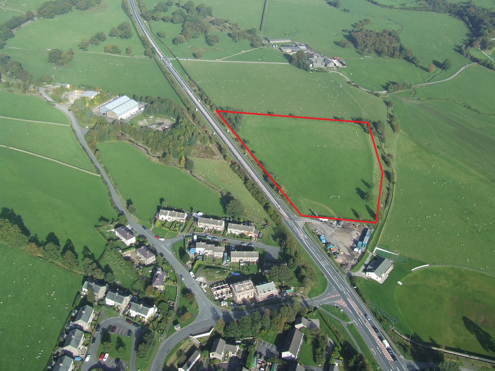
This is the preferred landing field. It is the former football pitch east of Threlkeld and next to the car park to the south east of the A66.
It is shown by an 'L' on the site map. Also refer to photo 1 for more detail.
Check you know which is the Landing Field before you take off (although called the Football Field, the goalposts are long gone). Do not confuse it with the school playing field in the middle of the village which does have goal posts, but would be a VERY dangerous choice of landing).
There are two sets of power lines in the adjacent field immediately to the South of the landing field. These run from the bottom of the cricket pitch to the corner of the landing field and were the scene of a terrifying paragliding incident a while back.
Do not land in any neighbouring fields.
'SECONDARY' / UPPER LANDING FIELD (OCCASIONAL USE ONLY)
We have gained recent permission to use a field at the foot of Blease Fell. It is the field south east of High Row Farm. It is shown by an 'L' on the site map. Also refer to photo 2 for more detail.
HAZARDS are: it slopes, there’s hedges, dry stone walls, it’s not very big and there’s a footpath runs through the middle. Inexperienced pilots should check it out on foot before you use it. Suggested: if you can’t slope land don’t use it; if you need a windsock to judge wind direction don’t use it.
DO use this upper landing field:
- During April if there are sheep in the preferred lower landing field (the old football pitch).
- If you’ve got too low and can’t make the lower landing field.
DO NOT use this upper landing field:
- If it has ewes with lambs, or if it is in hay (very long grass); OTHERWISE it’s OK to land with stock in it.
Please, only use it OCCASIONALLY; Not every time you fly Blease! Don't abuse the goodwill that has enabled this. Likewise, DO NOT park on the road to make it more convenient! Use the lower field if you can.
FELL LANDINGS
"Top" landing, at or behind take off, is excellent on the large, broad, grassy shoulder. Bracken and rocks can make other places hazardous.
Landing on the small track leading north west out of the car park ( the "old landing area") is demanding due to the performance of modern paragliders and the trees causing turbulence. (Do not assume that if other pilots are landing here it is safe to do so, use your own judgement and experience)
Flying
Probably the most demanding site in the North Lakes area. The flying and the lift generated can be very intimidating. It has been known for pilots to take off and spend the next hour in big ears before getting below take off.
Pilots must be very comfortable in strong thermals and be confident at landing in the designated fields.
If flying here for the first time, please get a site briefing from an experienced local or contact the site officer, Chris Little 07307864418
Always keep a check on the wind speed and your ground speed when flying here. There are no escape routes if being blown backwards Push forwards early if in doubt
XC potential
Excellent potential both downwind and, in the right conditions, for achieving large 'triangle' flights. Take great care to keep well forward of windy gap if traversing west towards Skiddaw. Keep a check on your ground speed and push forward to avoid being blown back if the wind picks up (take particular care with this when flying along the back ridge)
Photos
Click on the photo for a full size image.
| 1. This is the 'MAIN'/ LOWER LANDING FIELD, clearly marked in this photo. It is the former football field SE of Threlkeld and south east of the A66. Note the goalposts have now been removed. Avoid landing in neighbouring fields. Photo by Dave Horne |
 |
| 2. This is the 'SECONDARY'/ UPPER LANDING FIELD at the foot of Blease Fell. It is south east of High Row Farm on Blease Road. |
 |
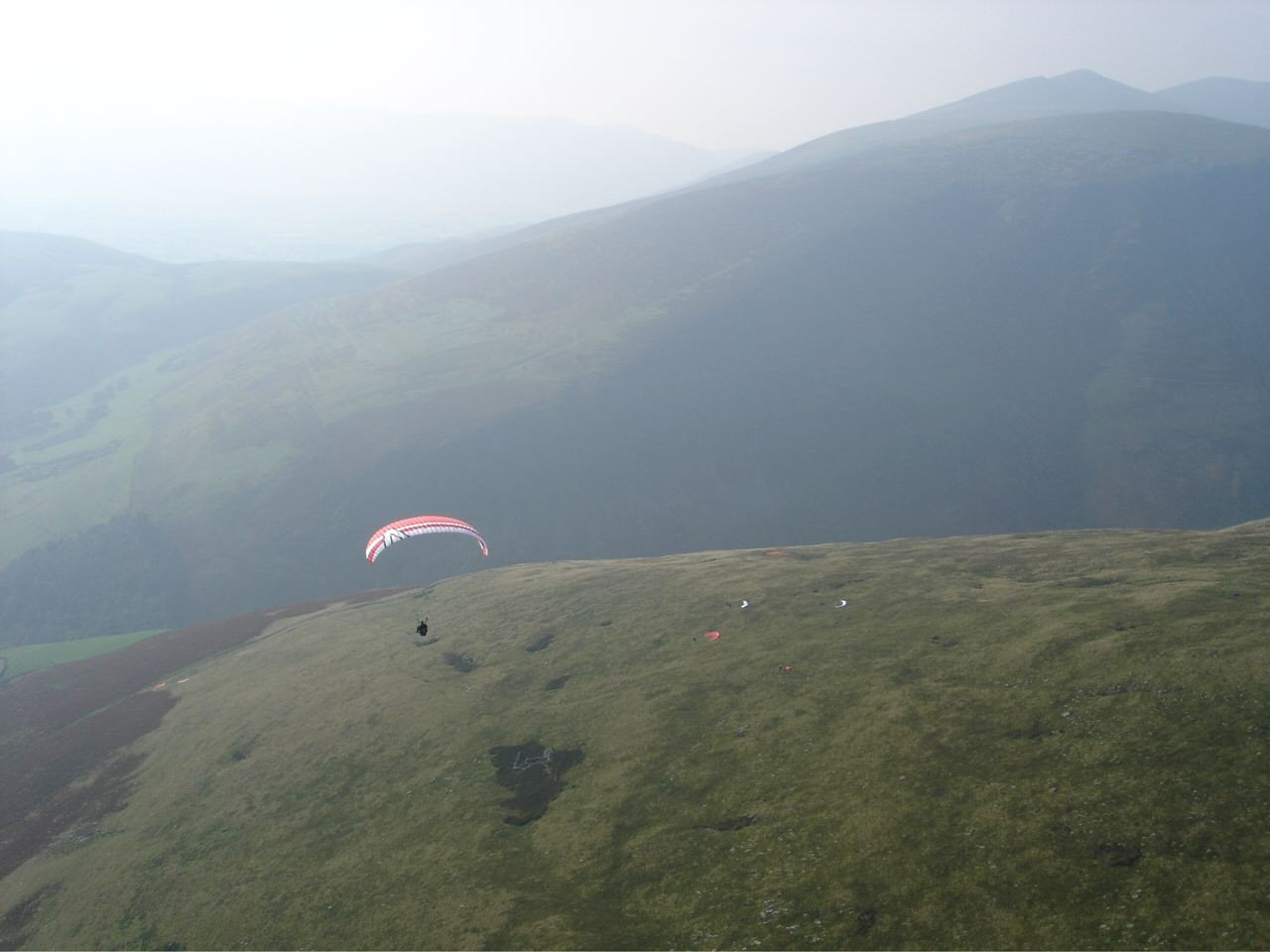
| 3. An aerial view of Blease Fell looking NW. Take off is about half way up the fell in the centre of the picture. Photo reproduced with the permission of the copyright owner, Andrew McMahon. |
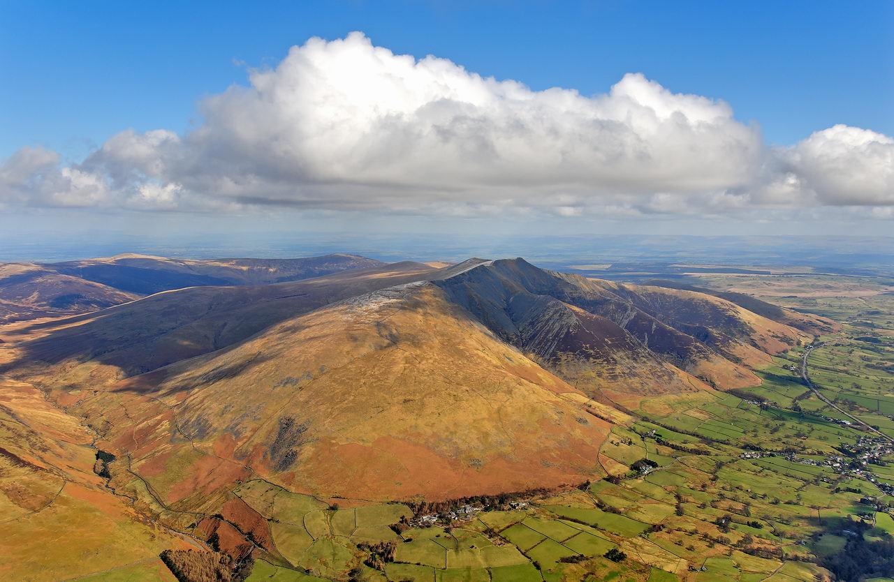 |
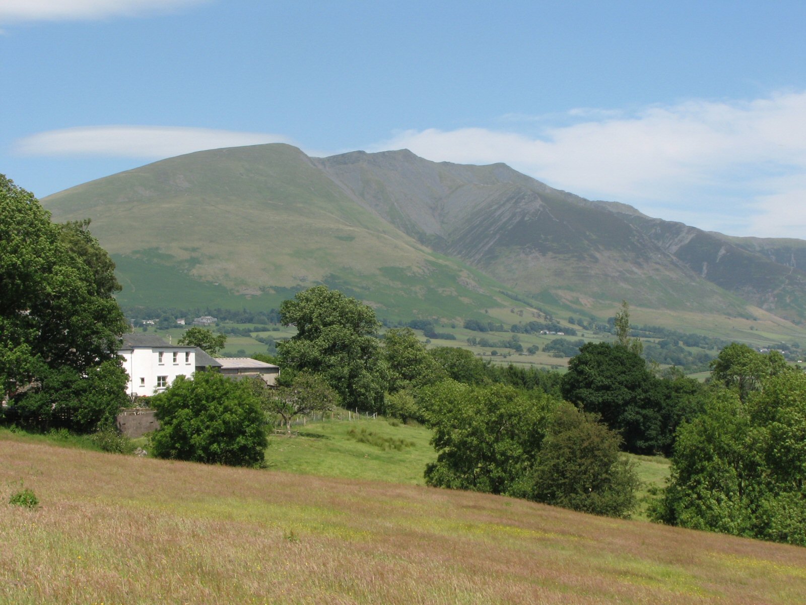
| 4. A general view of Blencathra from SW. Blease Fell is the grassy western flank of the mountain, dominating the centre left of the photo. |
 |
| 5. Looking down on the take off area. On the left of the picture, 2 wings have landed on the side of the walk up track which continues down through the bracken. To the left of the flying wing, the walk up track continues up to the ruined building in the foreground. This is on a "shelf" which marks the general take off area. Photo by John Hamlett |
 |
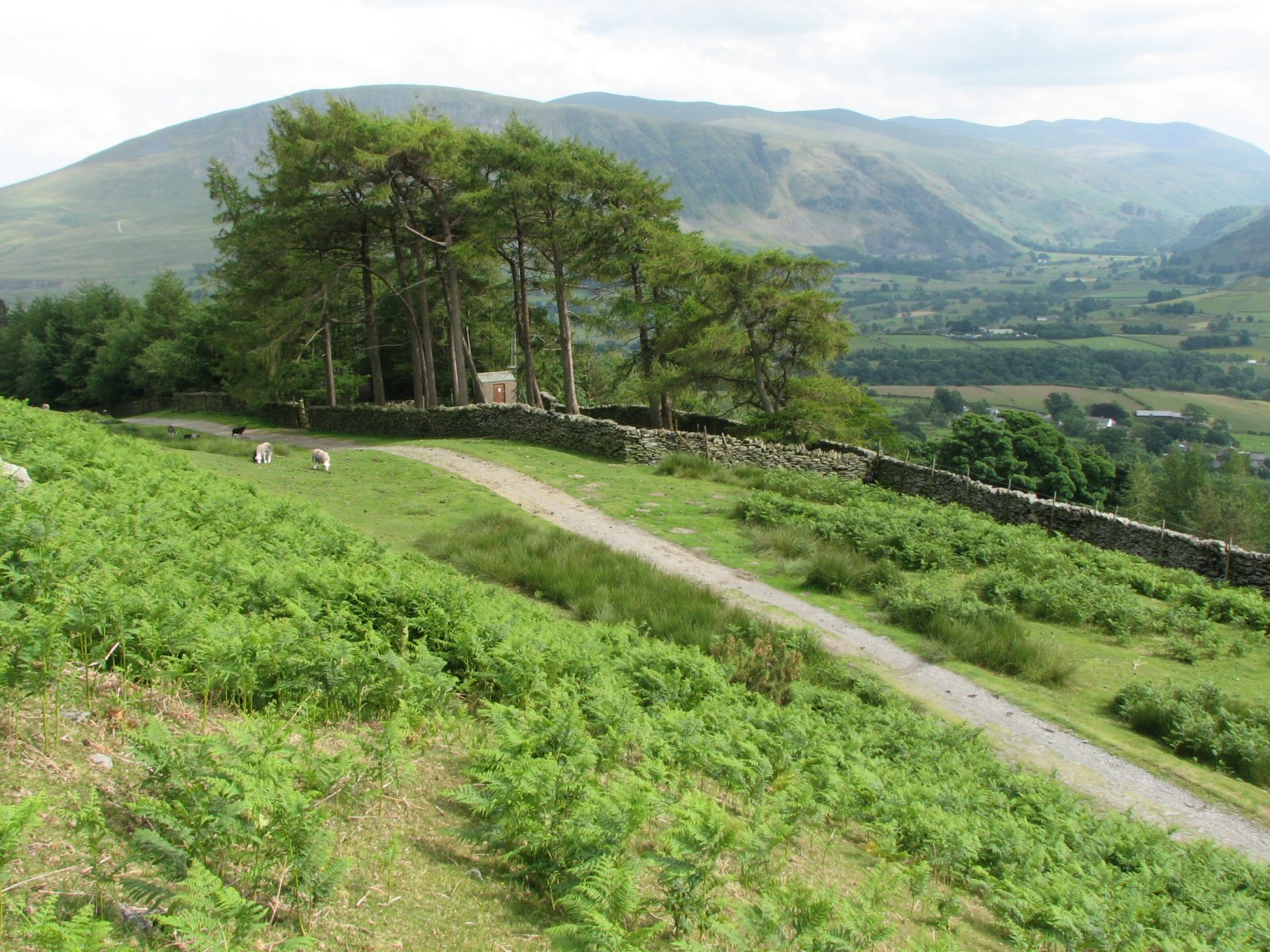
| 6. The restricted area near the car park on Blease Fell. Landing here is no longer advised due to modern paraglider performance and the trees causing turbulence. |
 |
Local Information - Pubs/Food etc
Nearest pubs to the site - for post flying debriefing only! You may find details of other facilities here
| Horse and Farrier, Threkeld | |
| Grid Reference : | NY322254 |
| Distance from Site : | 1.3 miles |
| Notes : | A Jennings pub in Threkeld immediately below Blease Fell. The Treasurer reports that the food is excellent! (Oct 2010). |
| Click here to go to the web site | |
| Click here to see the place in Google Street View |
This page shows records for this site. Some of the older records are not very detailed. More recent records may have an igc file available You can right click and download this to your PC. You can then use IGC Flight replay to view the flight.
| Paragliding |
| Declared Out and Return | |
| Distance : | 38.2km |
| Date : | 03/06/2012 |
| Pilot : | Multiple Pilots |
| Notes : | A number of pilots completed this as an LCC task (this became briefly a National Declared Out and Return record). |
| IGC File : | Right click to download |
| FAI Triangle | |
| Distance : | 49.9km |
| Date : | 27/04/2011 |
| Pilot : | Phil Wallbank |
| Notes : | Record triangles also set this day on CatBells (Rod Welford -49.6km) and at Wrynose (Mike Cavanagh - 50.9km) |
| IGC File : | Right click to download |
| Turnpoint Flight | |
| Distance : | 108.9km |
| Date : | 11/07/2009 |
| Pilot : | Mike Cavanagh |
| Notes : | The flight that broke the 100km straight line record from a Cumbrian flying site. The flight took 3 hrs 20 mins from Blease to Crawford in the Clyde valley. |
| IGC File : | Right click to download |
| Hang Gliding |
No hang gliding records available for this site
Data Resources
Follow the links to see the site in Google Earth and Google Street view. To access the former, you will need to have Google Earth installed on your PC. You can also upload your flights to GE - use GPS Dump (Links Page) to convert a variety of GPS file formats to a GE kml file.
| Link | Resource Type | Notes |
|---|---|---|
| Google Earth - Car Park | ||
| Google Street View - Parking | Google Street View doesn't go any further but you're almost there. Continue up the track on the right over a cattle grid. Parking can get busy. |
Blease Fell Map |
Legend |