SE |
Bleansley |
| Status : | OK | ||
| IMPORTANT - Restrictions on use | As imposed by the farm. | ||
| Last Updated : | 15/12/2021 at 19:16 by Ian Henderson | ||
| Wind : | SE | ||
| Nil Wind : | No | ||
| Grid Ref : | SD204895 | Height (AMSL) : | 500' / 153m |
| Site Code : | 17.056 | Top to Bottom : | 456' / 139m |
Location
S Lakes - nr Broughton-in-Furness
Details
This site is very rarely flown and is one for the pilot who has got bored with everywhere else. A clean take off area and a short but pleasant ridge. One big plus is its proximity to the "Manor" in Broughton; best ale's in the world!
Local Sites Contact - Keith Paterson mobile 07841 056727
Site Officer
Keith Paterson : 07841056727
Postcode for Sat Nav Systems (read the Health Warning!)
LA20 6AR - This is the closest mail delivery point to the flying site and is positioned at:
Between Low Bleansley and Middle Bleansley Farms
Getting There
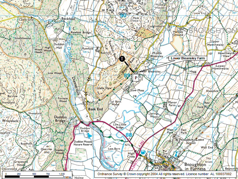
A595 (T) to High Cross. Turn R on A593 to Coniston. After 3.5 km turn left and left again at Lane End; a minor road leads down across valley to the Lower Bleansley Farm (a map is useful).
Getting to takeoff
Directly up front of hill above the farm. An alternative is to walk up the back of hill from the Duddon valley.
Permission to use site
Lower Bleansley Farm.
Additional Safety Notes
Can be rough as air comes over rising ground before the ridge.
Paragliding
Few reports from PG pilots but is said to be anywhere between OK and rough.
Hang Gliding
Not really worth the carry ... go to the pub instead (see above). Alternatively, go to the High Cross Inn, buy a drink and, from their balcony, watch someone else carry up.
XC potential
Limited potential but would be a good challenge to get to the Combe; getting back would be even better!
No photos available for this site. Good quality photos of CSC sites always required.
Local Information - Pubs/Food etc
Nearest pubs to the site - for post flying debriefing only! You may find details of other facilities here
No pub details are available for this site. Send your recommendations to the webmaster.
This page shows records for this site. Some of the older records are not very detailed. More recent records may have an igc file available You can right click and download this to your PC. You can then use IGC Flight replay to view the flight.
| Paragliding |
| Turnpoint Flight | |
| Distance : | 14.6km |
| Date : | 17/08/2016 |
| Pilot : | Chris Tyson |
| Notes : | A flight from Bleansley to the SE running along the southern flank of Black Combe and ending on the beach at Silecroft |
| IGC File : | Right click to download |
| Hang Gliding |
No hang gliding records available for this site
Data Resources
Follow the links to see the site in Google Earth and Google Street view. To access the former, you will need to have Google Earth installed on your PC. You can also upload your flights to GE - use GPS Dump (Links Page) to convert a variety of GPS file formats to a GE kml file.
| Link | Resource Type | Notes |
|---|---|---|
| Google Earth - Car Park | ||
| Google Earth - Take Off | ||
| Google Street View - Parking | This is as far as Google Street View goes - follow the lane on the right |
Bleansley Map |
Legend |

