| Please read the News Section & Site Alerts sections before flying | Members - the last announcement was sent out by e-mail on 30/05/2026 at 12:55. Log onto the members only area for details |
|
Welcome to the Cumbria Soaring Club Website
The Home of Paragliding and |
 |
|
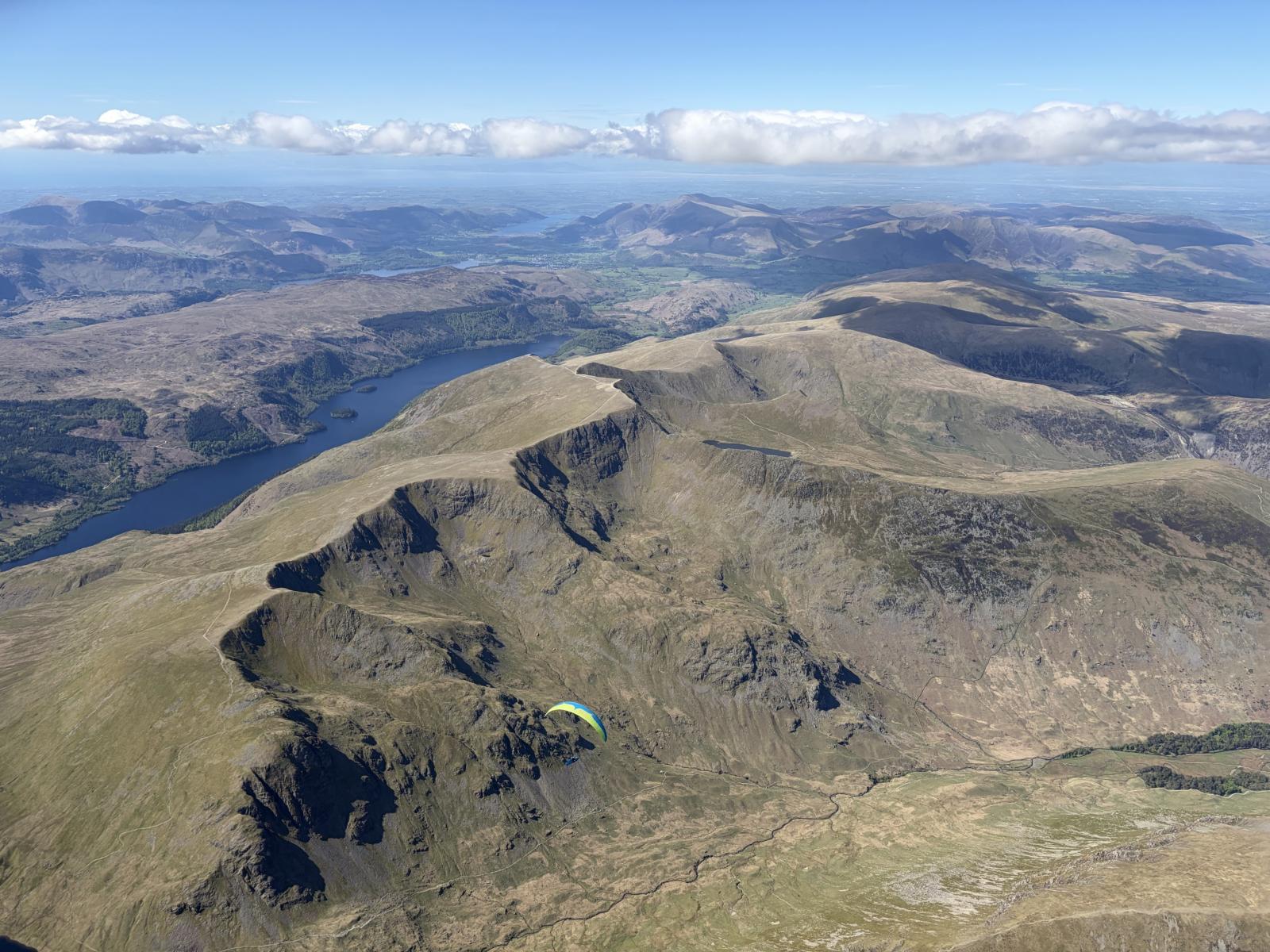
| June's Picture | Jacob Aubrey flying the Helvellyn range on 10th May as part of the North-South Cup. Picture by Tom Hodgkin. | |
|
Click on the picture for a better resolution photo. Got a good picture of flying in Cumbria? Get it to the webmaster and the best of the month goes here! An archive of previous pictures can be found in the CSC Gallery |
Current Flying Site Warnings
Only sites with active warnings are shown below. See the sites guide for details of all sites
RED - Site closed. Do not fly!
AMBER - Warning in place. Site can be flown but abide by warning
| Site | Alert Details |
|---|---|
| Carrock Fell | Whole site closed due to Peregrine nesting for all of April, May & June. |
| Ellerside | The site is closed April May June due to nesting peregrines. |
| Humphrey Head | Site temporarily closed at request of the Farmer. Please do not fly until negotiations have been made with the Landlord. (This site will be closed from 1st April to 1st of July due to nesting Peregrines) |
| West Fell / Sandbeds | TO LIMIT THE DISTURBANCE OF GROUND NESTING BIRDS. From the 01st March through to 31st July: Stay on the tracks/paths, limit wandering about and watch where you put your feet NO GROUND-HANDLING sessions please. |
| Whitbarrow Scar | The site is closed April May & June due to nesting peregrines. |
WINDER
Winder (SD 65407 93282) is a hill at the south end of the Howgills overlooking Sedbergh. The CSC requests that no pilots fly on this hill. We DO NOT have any permission to fly on this hill and, by ignoring this request, you will seriously put at risk our access to more important and valuable CSC sites both in the North and South Lakes areas.
 We are lucky to do our flying in one of the most beautiful areas of the U.K. and it is thanks to the goodwill of the farmers and other landowners, who allow us access to the hills and fells, that the CSC sites are open to all visiting pilots. The Club does not, at present, operate a 'Members Only' policy on any of its sites.
In order to maintain this situation, it is vital for all pilots to stick to the Site Rules. Please use our online Sites Guide for up to date information relating to access to Cumbria Soaring Club sites.
The Cumbria Soaring Club holds an annual event called the 'Lakes Charity Classic'. The aim of this gathering of pilots is to raise money for local charities and, in past years, we have donated substantial sums to; The Calvert Trust and 'Flyability; Mountain Rescue Teams based in and around the Lake District area; local village halls and other benevolent charities.
Although you don't have to be a member of the CSC to fly in our area, we welcome members from all parts of UK and abroad and we would appreciate your support. So join our Club and support flying in the area. The Club's annual fees are very low and the flying is fantastic. If you wish to join the Cumbria Soaring Club then visit this page this page and complete the online mebership application form.
New Pilots
We want to help you make the transition from a student with a gleaming, new CP rating to flying in the Lakes and making your own decisions. During the flying season from April to October we run coaching days, generally on the 1st Saturday of the month - see the events page for details. Here, club coaches will introduce you to our sites and help you build confidence. This isn't training - it's the next step to becoming a competent pilot. We have two Telegram Groups. CSC Members Chat provides a platform for CSC members to chat and exchange information. It is a closed Group intended for CSC members only by invitation. A separate Group Cumbria Flight Plans & Site Conditions has been set up to allow pilots to share information relevant to flying on the day. It is also a place to share information on NOTAM’s and information on military low flying activities. This Group is open to non CSC members by invitation. If you would like to join these groups, contact the CSC Membership Secretary. Also you can join our forum - you don't have to be a member. Here you'll find discussion on safety issues, and many other topics.
 It's a common misconception that the Lake District is "open" land and is owned by the National Park - it isn't! The Lakes is an area of mainly mountains and rough fell with the limited amount of flat valley space at a premium. The main crop is sheep, in particular the Herdwick sheep. This is the bottom end of the farming community. It's hard work and you don't find many rich farmers here. The Lake District Planning Board keeps a tight rein on development so that they can't just replace a wall with a barbed wire fence.
By and large the farmers are great folk. They're a bit wary of strangers but if you take the time to talk to them, you'll have a great time. Don't forget that their dominant crop is the annual lambing which just happens to coincide with the start of our main flying season. Lambing comes late to the Lakes with the high fell flocks lambing in April and May. The ewes are generally brought down from the fells into the valleys where the actual lambing takes places. The key part of the process is the subsequent "hefting" where the ewes and lambs go back onto the open fell. Hefting is a traditional method of managing flocks of sheep on large areas of common land and communal grazing. Initially, sheep had to be kept in an unfenced area of land by constant shepherding. Over time this has become learned behaviour, passed from ewe to lamb over succeeding generations. Lambs graze with their mothers on the "heaf" belonging to their farm instilling a life long knowledge of where optimal grazing and shelter can be found throughout the year. This critical hefting period is the one that farmers don't want us to disturb.
Their second crop is the grass in the valley fields. So if a field looks long and lush then it's usually about to be cut. Don't land in it as that's the animal food supply for the winter.
So
- All land in the Lakes is owned by someone
- Folk generally don't get too concerned about land above the intake wall, the highest wall on the fellside
- Valley land is valuable. Treat it with care and stick to the footpaths
- The walls have taken centuries to evolve. They take a lot of work to rebuild. Don't climb over them.
- Lambing time is the main time in the year when the farmer makes his money - don't fly if a site is closed
- There are some rare birds nesting in the Lakes - keep away from nesting sites
A couple more things to remember when flying here. First, most of the ground away from the valleys is rough. There aren't many sweeping carpets of grass. Be very careful in picking your landing site as a meeting with a rock doesn't help the complexion. Second, mobile phone coverage in the Lakes is poor. The planning board doesn't like the masts so there aren't many of them. Also, the fells tend to get in the way of a good signal. In most valleys away from the honeypots, you will not get a signal. You're unlikely to get a signal until above 1,000/1,500 ft and then only when you can see somewhere populated. If you intend to fly the high fells, make sure someone knows where you're going.
Last point on footpaths. If you use a OS 1:25,000 map then the green footpath lines can be a figment of the map draughtsman's imagination. Sometimes, they don't exist on the ground. The green track up Blencathra across Blease Fell is an example. Look for the black pecked lines that are barely visible - this is where the real track will be.
CANP (NOTAM) Procedure
The CANP procedure (commonly referred to as a NOTAM, which it isn't) is a way of informing low flying military aircraft of where we will be flying. The technical definition is
A voluntary system whereby civil operators notify their intention to fly at low level (at or below 1,000 feet agl, when crop spraying or powerline inspecting for example), aimed at avoiding conflict with low flying military aircraft.
The military don't tend to fly at weekends or bank holidays but the Red Arrows are an obvious exception.
The best way to register a CANP is to use this web site. Click the "Send in CANP" option to enter your details.
If you submit a CANP, you may receive a call from the RAF low flying unit. They may want a few more details on when and where you expect to be flying. They may also provide you with some details about their own flying plans through the Lakes area. If you receive such a call, please provide a summary of what was said on the Cumbria Flight Plans & Site Conditions Telegram Group. We want to encourage this type of communication between paraglider pilots and the RAF Low flying unit.
If a NOTAM has been issued and you then change your plans on the day, remember that other paraglider pilots may be headed to the site, so unless conditions make it highly unlikely, don’t say that no flying will take place at the site.
There is more info about the CANP procedure on the BHPA web site which you can read about here.
Airspace Considerations
As Cumbria is a long way from major airports, both civil and military, it's easy to think that we don't have to worry about controlled airspace. However, if you're planning to ride that magic thermal to over 9,000ft, you need to think controlled airspace. The main issue in Cumbria is military low flying but it is important to consider the dense air corridor above us.
- Low Flying
- Danger Areas
- Restricted Areas
- Airfields
- Airways
- Eden Soaring Club
- Eden Valley Model Aero Club
- Airprox System
 Being a mountainous area, Cumbria gets a lot of low level traffic, mainly from the RAF but also from other NATO forces. Most aircraft will be transiting through Cumbria on their way to somewhere else, frequently from bases in Southern England to Scotland, or to the ranges at Spadeadam in Northumberland.
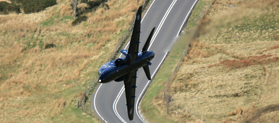
Normally, they will be flying in the valleys keeping well away from the ridge lines. If they fly over a ridge they may go partly inverted so that they don't lose sight of the ground. Tucano training aircraft may behave differently - these are the black turbo prop aircraft with straight wings In the early stages of training, student pilots will be flying straight legs between well defined visual waypoints, like Killington Reservoir. From a free flier's perspective these are the ones to watch out for, a) because they're flying over the hills instead of in the valleys and b) because most of their attention will be on flying the aircraft; the look-out may not be getting a lot of their time!
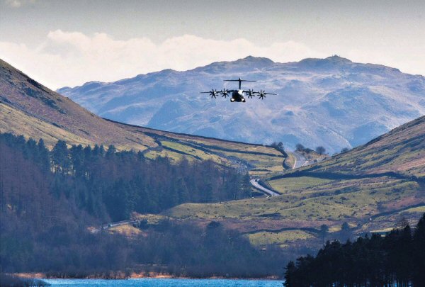
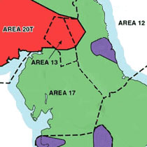 Cumbria lies in Low Flying Area 17 and standard low flying height in Cumbria is 250ft agl. Go here for further information about military low flying. The common route in Cumbria is up Windermere, over Dunmail Raise, Thirlmere and past Keswick, frequently going up the gap between Skiddaw and Blencathra. In the Southern Uplands of Scotland, low level flying can take place at 100ft agl. Aircraft can fly at up to around 420 kts which is around 7 miles a minute. Frequently you will hear them long before you can see them. Tucanos will fly slower at around 240 kts. As well as fast jets, you will see Hercules transport aircraft flying at low level and they make a pretty impressive sight when flying up Thirlmere. A Hercules will be trailing a very dynamic wake so keep well clear of their track for several minutes and watch out for the wake being blown downwind.
Most sorties are flown during weekdays. They do fly on weekday evenings and at night. Friday afternoons are generally quieter and there is no low flying at weekends.
Although you won't see fast jets at weekends, you will probably see the Search and Rescue helicopter flying round the Lakes. Sometimes they will be on an emergency, sometimes training with a local Mountain Rescue Team and sometimes they're having a look round. The good news is that they fly fairly slowly and make a lot of noise. You can usually hear them coming for some time.
There's very little you can do to keep out of their way. The best way is to make sure that you register your weekday flying through the CANP procedure which is detailed on the CSC forum. Bear in mind that it can take around 4 hours planning for a sortie and they may have started to walk out to their aircraft at least an hour before arriving in Cumbria. So get your call in early.
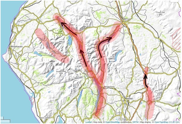
The map below shows the primary low flying routes through the Lake District.
A number of danger areas affect Cumbria
- Warcop EG DG407 - This danger area covers an Army Training area on the Pennines to the south of Appleby. It's an extensive area of what could be a good South Westerly flying area. The height of the area is normally 10,000ft but it is occasionally increased (via NOTAM) to 13,500ft. In January 2009, the advertised opening times were Mon-Sat 0730-0200 Sun 0730-1300 in Winter and 1 hour earlier in Summer. Unlike the RAF, the Army do work weekends as a lot of Territorial Army training takes place then. Watch out for this area if you're thinking of flying XC to the East coast.
- Eskmeals EG DG406 - This danger area covers operations by the Eskmeals gun range. According to the Qinetiq web site, "This facility offers weapon and equipment proving trials over land at short-ranges (to 1.5km), and over the sea for long-ranges (to 49.0km) from 10 operational firing locations." Basically they fire shells out to sea to see if they work properly. You wouldn't want to extend your coast run from Silecroft when they're firing! As most of the operations are out to sea, this area doesn't really affect us. The height of the danger area is 50,000ft with occasional extensions to 80,000ft. Hours are Sep to March 0800-1700 (1 hr earlier on BST) and April to August 0700-1900.
- Spadeadam EG D510 - This danger area is tucked away in the north east extremity of Cumbria. You definitely don't want to go anywhere near here on a paraglider or a hang glider! According to the RAF website "RAF Spadeadam is the only facility in Europe where aircrews can practice manoeuvres and tactics against a variety of threats and targets that they face in contemporary warfare. This fascinating facility attracts aircraft from the RAF, Army, Navy and NATO Forces." So think very fast aircraft flying very low, surface to air missiles and pilotless aircraft. The height is 5,500ft with occasional notification to 18,000ft. Opening hours are Mon-Thu 0900-1700, Fri 0900-1600 (1 hr earlier in summer). Another reason for keeping away from here is that part of the site is run by Advantica who say on their web site "With over 20 years experience in studying gas cloud explosions, Advantica are world leaders in the field."
- Sellafield EG R413 - A circle radius 2 nm centred on 54 25 05N 003 29 44W, height 2,200ft. This area covers the nuclear recycling facilities at Sellafield on the west coast, south of St Bees.
- Barrow in Furness EG R445 - A circle radius 0.5nm centred on 54 06 35N 003 14 10W. Submarine works at Barrow.
- Carlisle - is located about 5nm ENE of Carlisle and is the largest airport in Cumbria. The web site is http://www.carlisleairport.co.uk. The main runway is 07/25 (i.e. 070°/250°) so most approaches will be made from the ENE. Carlisle Tower is on 123.6. Major development plans are proposed for the airport with expansion plans being approved by Carlisle City Council on 19/12/2008. The airport currently caters for business jets, general aviation and microlights. A number of training/air experience schools are located on the airport.
- Kirkbride - is located in North cumbria to the North of Wigton. The web site is http://kirkbrideairfield.weebly.com/. The main runway 10/28 is so most approaches will come in from the east. The airfield caters for General Aviation, microlights and autogyros. The frequency is 124.4
- Barrow/Walney - located 1nm to the west of Barrow-in-Furness on Walney island. The web site has disappeared but the Lakes Gliding Club operate from the airfield http://www.lakesgc.co.uk//. 3 runways are in use - 12/30, 06/24, 17/35. An Instrument landing System is provided for runway 35, i.e. to the North. The airfield is used by business aircraft, general aviation and gliding. Watch out for tugs climbing out with gliders.
- Cark - is located on the southern end of the Cartmel peninsula in South Lakeland. The web site is http://skydivenorthwest.co.uk/. This airfield is the closest to any of our sites as aircraft on final approach will normally pass just to the north of Humphrey Head. The airfield is mainly used at weekends and parachutists are dropped from a variety of heights over or near the airfield.
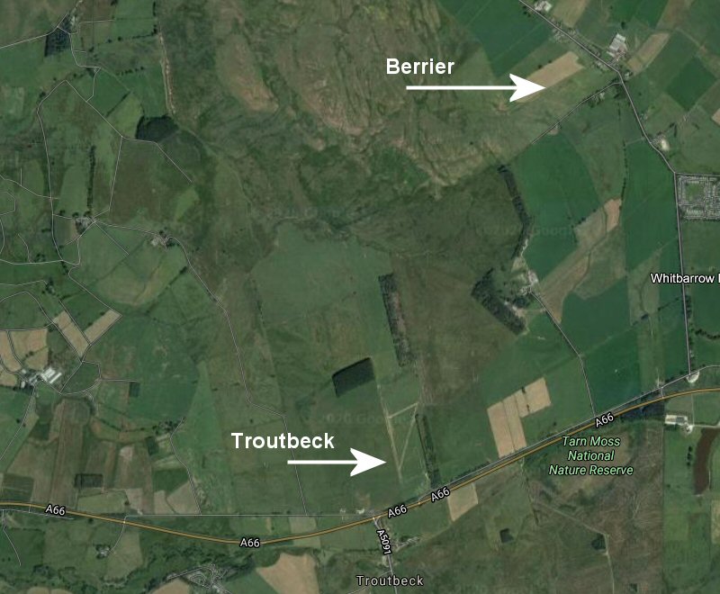
- Berrier - is an airstrip in North Cumbria sited 2km NNE of Troutbeck on the A66 between Keswick and Penrith. The location is NY 39881 29461 and the grass runway is orientated 060/240. Lake District Gyroplanes (https://www.lakedistrictgyroplanes.co.uk/) operate out of here. They run air experience flights and gyrocopter training flights. A gyrocopter is a type of rotorcraft that uses an unpowered rotor in free to develop lift. They haven't got a tremendous climb ability so they will use hill lift to gain height but are unlikely to get as close to the hill as us. They tend to transit at around 500 to 1000ft agl. A typical air experience flight would involve a circuit of Keswick - Newlands - Langdales - Ambleside - High St whereas a longer flight would take in Ennerdale, Scafell and Coniston. Flying hours on a good day would be from 0900 to last light. If you see them, put in an orbit so they get a better chance of seeing you. Listen out on the radio as they know the frequency we operate on.
- Troutbeck - is an airstrip in North Cumbria sited immediately NNE of the junction at Troutbeck on the A66 between Keswick and Penrith. The location is NY 39060 27567. They have 3 grass runways which you can see on Google Maps. The main runways are 350/170 and 030/210. At the moment, one gyrocopter is based here but the strip is getting used by light aircraft.
An airway is a motorway in the sky. Airways traffic used to fly from VOR navigation beacon to VOR so a lot of the UK airways were aligned with those corridors. The standard width of an airway used to be 10 nautical miles, centred on the track from beacon to beacon. The initial shape of the airways over Cumbria was derived from the position of 3 of these VOR beacons. The 3 beacons that affect Cumbria are
- Pole Hill - north of Todmorden - 53° 44' 37"N 02° 06' 12"W
- Wallasey - on the Wirral, west of Birkenhead - 53° 23' 31"N 03° 08 04"W
- Dean Cross - east of Maryport - 54° 43' 20"N 03° 20' 26"W
Although the airway from Wallasey to Dean Cross hasn't changed much, the airway from Pole Hill to Dean Cross has expanded considerably, width-wise. Now, only the following areas in Cumbria are not under an airway
- West coast, north of Sellafield to south of Workington
- A small area of the east Furness peninsula
- The Pennine area, roughly east of the Settle to Carlisle railway
The western airway from Wallasey operates at weekends only and has a base of FL155. You're going to be hypoxic before you get to the base! The eastern airway is a lot more complicated.
- The lowest part is south east of J36 on the M6, i.e. Farleton Knott; this has a base at FL75. However the base is raised to FL125 from 0700 to 2000 (1 hour earlier in Summer). As you progress towards Lancashire and the Manchester control area, the base is steadily stepping down in height.
- The majority has a base of FL95, again raised to FL125 from 0700 to 2000 (1 hour earlier in Summer)
- Other smaller areas have a higher base which shouldn't normally affect us.
Under normal circumstances, we're unlikely to go into an airway over Cumbria. However, it's important to recognise that non-airways traffic, flying the same route, will normally fly using the VOR transmitters for navigation and will sit under the base of the airway. Therefore the VOR to VOR track under the airway will be an area of relatively high density traffic. Aircraft should be flying the quadrantal rule which will give you an idea of their heading
- Magnetic Track 000 to 089° - odd thousands of feet (FL 70, 90, 110 etc)
- Magnetic Track 090 to 179° - odd thousands + 500 ft (FL 75, 95, 115 etc)
- Magnetic Track 180 to 269° - even thousands of feet (FL 80, 100, 120 etc)
- Magnetic Track 270 to 359° - even thousands + 500 ft (FL 85, 105, 125 etc)
These aircraft are likely to have the VOR to VOR route programmed into their autopilot, so the pilots may be letting the autopilot do most of the work.
Eden Soaring Club fly gliders from a field near to Cross Fell on the Pennines. Their flying season runs from the beginning of April to the end of October. The centre of their flying field is NY 62417 33858 near Skirwith. The field is on a bearing of 070 degrees, 7.15 miles from the centre of Penrith. The landing field can be seen on Google Earth and is outlined in red below
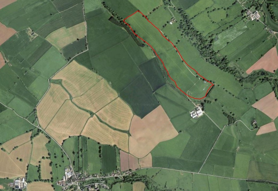
Note that the runway is aligned in a NW/SE orientation. Although a stone wall bisects the site (with a gap!), operations take up the full width of both fields. The winch will be sited at one end and take off will be at the other end. Circuits normally use the NE side of the landing field. Stored gliders are kept at the SE end - so don't confuse these with the take off area. The winch is a blue and yellow device that looks like a big trailer. The winch operates 2 cables so don't assume that everything is clear after a glider has launched.
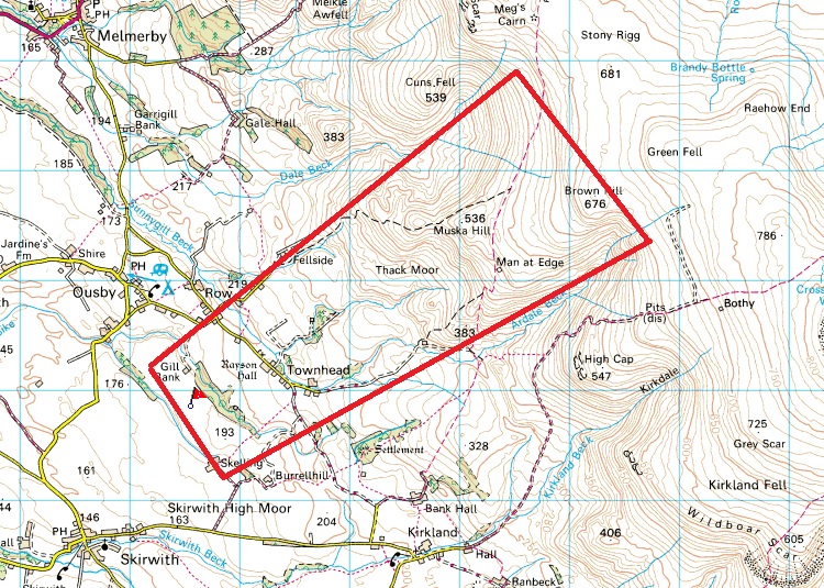
They use a powerful winch which quickly launches gliders to 1200/1500 ft agl depending on the strength of the wind. The rate of climb is fast so don't assume that a glider on the ground isn't going to be a problem. After take off, in prevailing wind direction conditions, the normal procedure is to fly directly to the Thack Moor/Muska Hill/Brown Hill area and work up the hill to gain height in a similar manner - but faster - to our technique. Note that this is very close to the NHPC site at High Cap, Cross Fell.
One area to definitely avoid is their final approach. Once committed to landing, they don't have many options for avoidance.
Eden Valley Model Areo Club operate from a field in NE Cumbria, near to Kirkby Thore. The landing field centre is at NY 62452 25203 and they can use the field to the west. It is 4.8 miles on a bearing of 307 degrees from the centre of Appleby. The field and the flight radius are shown below
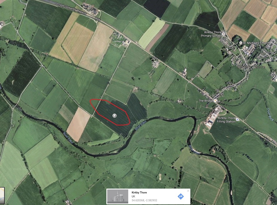
Flying is available on all days of the week and they will fly until dark. The normal maximum height above ground level is 400ft although this may be modified by NOTAM. They can operate model jet aircraft and these can fly up to 150mph - so they are small and fast! When they fly jets, the pilot is accompanied by a spotter whose task is to look out for other aircraft. A large windsock is erected whenever they are flying. The runway is 400ft long so should be visible from the air. It would be best to avoid this area.
An Airprox is a situation in which, in the opinion of a pilot or air traffic services personnel, the distance between aircraft as well as their relative positions and speed have been such that the safety of the aircraft involved may have been compromised. The airprox system is designed to support the whole of the flying community and is primarily a mechanism for assessing how an airprox occurred and the lessons that can be learned. Paragliders can and do use this system.
If you get in a situation where you believe that there was the risk of a collision or where another aircraft could have affected your stability, then you can raise an Airprox report. The airprox web site can be found at https://www.airproxboard.org.uk. We recommend that you contact the CSC safety officer who wil help you with filing a report.
Key Data for Monday, 8 June 2026
| Sun Rise : | 03:43 GMT | Sun Set : | 20:38 GMT |
Tidal predictions for Whitehaven can be found here
Today's Met Office Forecast for Ambleside
Weather Links - Click on the Icon for the Link
| WEATHER STATIONS IN CUMBRIA | |
| Ellenborough - on the outskirts of Maryport | |
| Keswick Schools Weather Stations - Mainly valley bound so may not give useful wind info | |
| High Hill - Just NW of Keswick pointing up the Coledale valley (WSW from High Hill). High quality web cam and weather station | |
| Penrith - a lot of information! Unfortunately, it doesn't state exactly where it is | |
| St Bees - on the coast south of Whitehaven | |
| UK WEATHER STATIONS | |
| Settle Covering Gargrave, High Bentham, Ingleton, Austwick, Long Preston and Stainforth |
|
| mylocalweather - The home site for local weather stations all over the UK | |
| OTHER WEATHER LINKS | |
| |
WeatherJack The font of all meteorological knowledge for free fliers! Lots of links and tutorials. The daily rating is now finished but still a good place to start |
| Regional Atmospheric Soaring Prediction Weather forecasting for free fliers, including information on all the key parameters that keep us in the air. Quite complex but very thorough. The Google Maps RASPTable is the simplest interface |
|
| XC Weather 3 hour wind history and 5 day forecast on a clickable map. Also available for France, Germany, Italy and Spain |
|
| Windy.com Interesting graphical picture of the wind flow together with an extensive range of other information |
|
| BBC Good basic stuff from the Beeb. Click here for the BBC Ambleside page |
|
| 5 Day Synoptic Charts 5 days worth of synoptic charts on one page - from a Dutch site using UK Met Office data. Alternatively use this site to click through 5 days |
|
| UK Met Office The link is for Ambleside. Follow links on the page for weather in other areas. |
|
| Keswick Area Weather Realtime weather data from a group of schools in the Keswick area |
|
| Lake District National Park 'Weatherline' 5 day forecast for the Lake District with links to the BBC 5 day forecast for Keswick and Windermere. In the winter, one of our members trudges to the top of Helvellyn several times a week to bring you the Fell Top conditions |
|
| Mountain Weather Information Service If you've seen the daily synopsis posted in various places in the Lake District, this is where you get it from. It appears to be a Scottish site but it also covers the Lake Distict, the Peak District and Snowdonia. The forecast is a pdf form |
|
| Skylink Lots of weather information for the UK including real time data |
|
| Weather Underground International weather information site |
|
| WeatherOnline Weather site with many forecast charts including wind arrows for the United Kingdom |
|
| BHPA Weather Links A link to the BHPA weather links page |
|
| Roger Brugge's Weather A page on the Reading University site with a comprehensive list of weather sites |
|
| Cloud Appreciation Society A web site and society dedicated to clouds. Lots of superb photos. The section on the Morning Glory cloud in Australia is especially recommended. |
|
| Weather Spark Interesting site that shows you actual history and forecast in a set of graphs. You can customise the graphs to add or remove elements. The link will take you to Ambleside. If you want a different location, always add UK in the search box as this is an American site. |
Getting Started

Learning to fly in Mallerstang, near Kirkby Stephen
How do you get started in paragliding? The place to start is a British Hang Gliding and Paragliding Association (BHPA) approved school. You can't fly with Cumbria Soaring Club until you have attained your Club Pilot (CP) rating, although you can join us as a Student and come to our winter social events. There are two BHPA schools currently operating in Cumbria.
1. Gordie Oliver at Air Ventures

2. Jocky Sanderson at Escape
Both of these schools offer a taster day as well as tandem flights so you can see for yourself if paragliding is the sport for you! There are approved BHPA operating overseas; they will tempt you with the offer of better flying opportunities due to the weather. If you are thinking of using one of these schools, our recommendation is to only do your Elementary Pilot (EP) overseas and return to the UK for Club Pilot rating. If you intend to fly in the UK, it's much better to get your first experiences of UK conditions under the eye of a UK based instructor.
Although we have tandem paragliders in the sport, your training will be conducted on a solo wing, closely supervised by a instructor on the ground and on radio. Initially you will start like the Wright brothers in 1903, making short hops on a gentle, grass covered slope. As your experience builds, you will walk further up the hill and start to learn how to make turns. Your first flight when you realise that you're not going down but are maintaining or gaining height is quite an experience!
For the EP phase, the school will loan you all the equipment to fly. We'd recommend that you are reasonably fit as the more times you walk up that hill, the more flights (and experience) you will gain. Once you move onto the CP stage, it may be worth completing your training on a wing you intend to use after CP training. Your instructor will have a good idea of you abilities by now and it's well worth considering his advice on what sort of wing to buy. Don't rush into buying a new wing. A lot of qualified pilots seek the next best paragliding wing so there are lots of good quality wings on the second hand market. However if you're buying second hand, always go through a paragliding equipment supplier - don't buy on Ebay!
A minimum equipment set will include :-
- Wing
- Harness
- Reserve Parachute
- Helmet
- Gloves
Once you've got your CP rating, you can participate in the coaching sessions run by Cumbria Soaring Club. You can get more details on this page.
Cumbrian Equipment Suppliers
Steve, Jan, Mike or Will at The Sick and The Wrong, Keswick

Richard, Pat or Mark at UK Airsports, Threlkeld