Souther Fell
North Lakes - SE of Blencathra
SE - ESE
Overview
An excellent site, renowned like its neighbour Carrock, for light winds.
The limit on the number of pilots (10) allowed in the air at any one time is frustrating, but must be adhered to. If the limit is seen to be flouted we stand to lose all access to the fell, and it may also effect neighbouring sites.
Important!
This site is extremely sensitive and subject to these rules:
Max 10 in the air at any time.
This site closes for lambing for the whole of April and May.
The club strongly recommends the use of a radio on this site (club frequency 143.700).
Schools and students are requested to give qualified pilots priority.
Do not land in any areas heading towards Carrock Fell, to do so will potentially lose us this site.
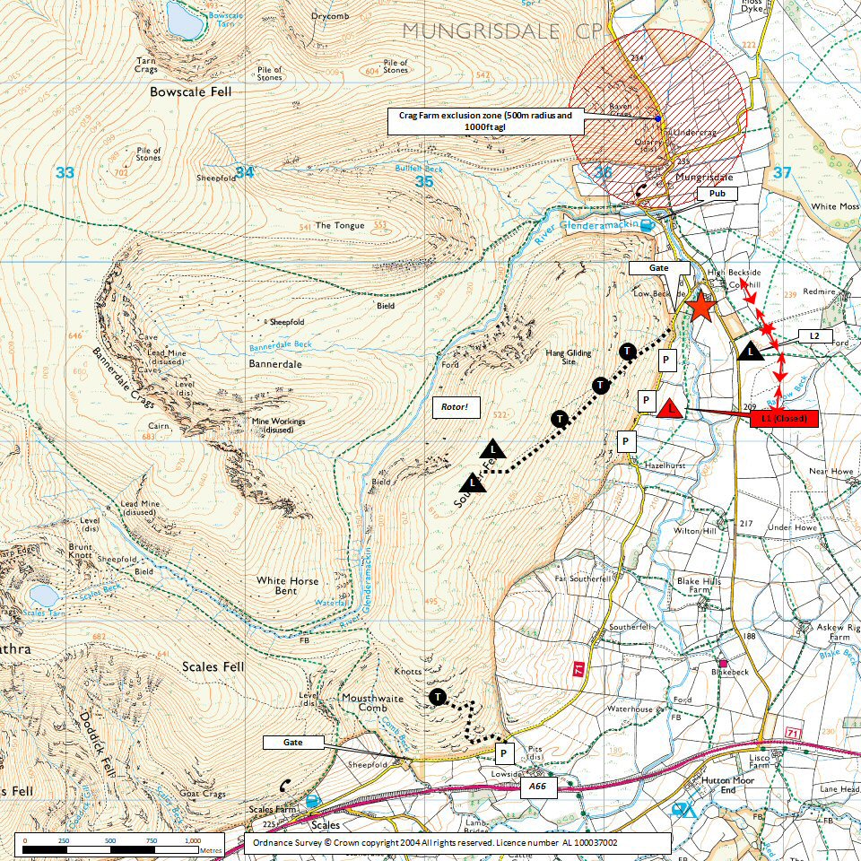
A permanent exclusion zone exists around Undercrag Farm. (500M RADIUS AND 1500FT ASL) Do not fly in this area. Again, to do so will potentially lose us this site.
Local pilot rep: Jonny Sims 07792460123
Access
Car park grid ref: NY366297
Getting There
Turn off the A66 Penrith to Keswick main road following signs to Mungrisedale.
After a mile and a half there is a layby on the right just before you arrive at Low Beckside farm.
If the layby is full there is roadside parking on the left of the road just past Low Beckside farm.
Getting to takeoff
The path up the fell starts 'here' beside Low Beckside farm. Follow the path over the stream and head left up the hill. Go through the fell gate and pick up the path immediately on the right. Follow this path diagonally across the face of Souther Fell until you are high enough to take off.
Permission to use site
Low Beckside Farm Mungrisedale. Caldbeck Commoners Association.
Flying
Hazards
Be wary of penetration problems in strong winds.
Power lines along the eastern end of the landing field.
Being blown back at Souther would be very dangerous. If you are concerned about windstrength, it is not much hardship to leave your kit at normal take-off and walk to the top to to check.
There is a farmer nearby who is not keen on flying activity. If confronted please remain polite and walk away.
Landing Areas
Use field L2
Note that permission from Low Beckside Farm is only required if there is stock in field L2.
Easy top landing and slope landing above the bracken.
Flying
Thermals well. Wave and convergence are occasionally found at the south end. It is possible to launch from the south end to fly Blencathra in SSE winds.
XC potential
Good thermal producer, and quite easy to get away, but the sea is only about 35 km downwind. Possible to cross to Carrock Fell if wind is off to the east, or onto Blencathra if off to south.


