SW - NW |
Latrigg |
| Status : | OK | ||
| IMPORTANT - Restrictions on use | - Limited to a MAXIMUM OF 10 PILOTS in the air at any time. - The CSC strongly recommends the use of a radio on this site (club frequency 143.700). - LAND IN DESIGNATED FIELDS ONLY i.e. the fields near the roundabout across the road from the caravan park (see Map) - Please use the site with care as it was only reinstated after a long period of no access. |
||
| Last Updated : | 24/03/2023 at 17:03 by Rick Livingstone | ||
| Last Reviewed : | 01/04/2022 by | ||
| Wind : | SW - NW | ||
| Nil Wind : | Yes | ||
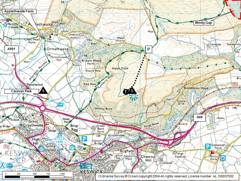
| Grid Ref : | NY277246 | Height (AMSL) : | 1180' / 360m |
| Site Code : | 17.067 | Top to Bottom : | 880' / 268m |
Location
N Lakes - N of Keswick
Details
A grassy hill which rises up from the north of Keswick. Access same as Jenkin Hill/Skiddaw.
The site is limited to a maximum of 10 gliders.
The SW slope is small and limited, Works best in a NW
Site Officer
Rick Livingstone : 07761187016
Postcode for Sat Nav Systems (read the Health Warning!)
CA12 4PH - This is the closest mail delivery point to the flying site and is positioned at:
Underscar Manor (Underscar hotel on map). The postcode centre is on the access road to the car park about 1km to the west.
Getting There
From the roundabout north of Keswick on the A66, take the northern exit A591 to Carlisle. Immediately on leaving the rundabout, take the side toad on the right (a caravan park entrance is on the right). Follow this road for around one and a half miles, where you will see another minor road trailing in sharply from the right. Takes this road which takes you up to the main car park for walkers climbing Skiddaw. On a busy day, parking can be difficult. Do not park on the fell side of the gate at the end of the car park. This is reserved for flying schools. You can drive through to drop gear off but do not leave your car here.
Getting to takeoff
From the top of the car park go through the gate and turn right. Latrigg is the rise in front. Go to the south or western side to find the best site for takeoff for the conditions.
Permission to use site
Negotiated by Northern Sites Officer
Hazards
Can be turbulent if the wind turns N of NW, when it comes over Skiddaw/Little Man
Take Off
large grassy, easy take off areas
Landing Areas
- Good top landing or slope landing area on the fell.
- Bottom landing options are those fields near the roundabout across the road from the caravan park (see Map)
- Beware of the big trees and sloping land in the field nearest the roundabout.
- The site may be closed during the lambing period, take care not to land near lambs or disturb livestock.
- DO NOT LAND IN THE FIELDS on the Latrigg side of the road.
Flying
A pleasant and attractive site with an easy walk to take off.
Most time however it does not work particularly well without an appreciable breeze.
Sea breeze usually kills it
Other local sites offer much better soaring possibilities.
XC potential
O.K. until it seabreezes then it is often poor.
Photos
Click on the photo for a full size image.
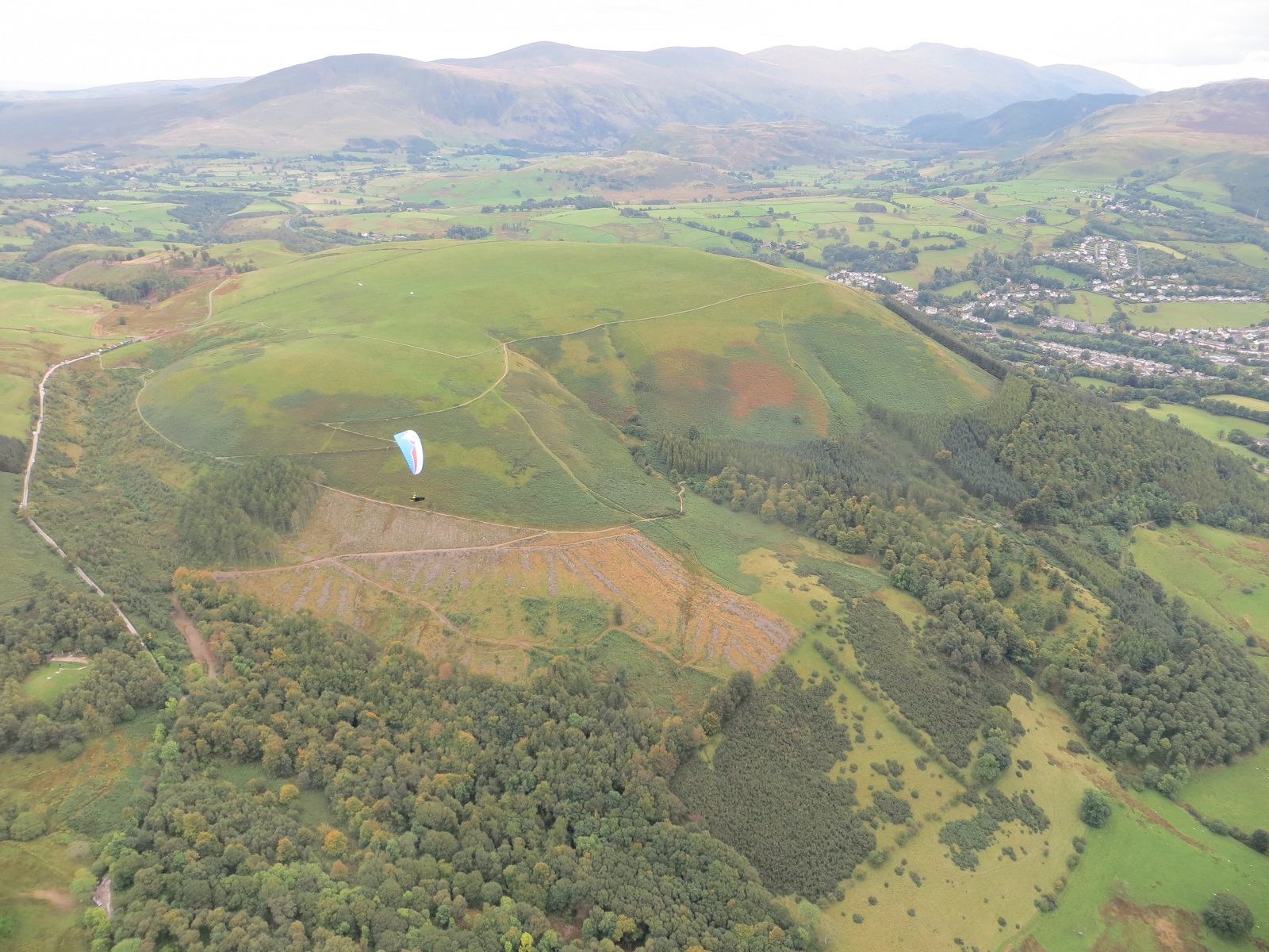
| A view of the Latrigg summit plateau from the North West. Clough Head and Helvellyn are in the background. Photo by Mike Harper |
 |
Local Information - Pubs/Food etc
Nearest pubs to the site - for post flying debriefing only! You may find details of other facilities here
No pub details are available for this site. Send your recommendations to the webmaster.
This page shows records for this site. Some of the older records are not very detailed. More recent records may have an igc file available You can right click and download this to your PC. You can then use IGC Flight replay to view the flight.
| Paragliding |
| FAI Triangle | |
| Distance : | 28.0km |
| Date : | 1997 |
| Pilot : | Patrick Holmes |
| Turnpoint Flight | |
| Distance : | 74.9km |
| Date : | 03/06/2017 |
| Pilot : | Philip Kew |
| Notes : | A virtually straight line flight from Latrigg to a landing between Haydon Bridge and Hexham. Duration 2hrs 34 min |
| IGC File : | Right click to download |
| Hang Gliding |
| FAI Triangle | |
| Distance : | 28.0km |
| Date : | 1997 |
| Pilot : | Patrick Holmes |
| Turnpoint Flight | |
| Distance : | 74.9km |
| Date : | 03/06/2017 |
| Pilot : | Philip Kew |
| Notes : | A virtually straight line flight from Latrigg to a landing between Haydon Bridge and Hexham. Duration 2hrs 34 min |
| IGC File : | Right click to download |
Data Resources
Follow the links to see the site in Google Earth and Google Street view. To access the former, you will need to have Google Earth installed on your PC. You can also upload your flights to GE - use GPS Dump (Links Page) to convert a variety of GPS file formats to a GE kml file.
| Link | Resource Type | Notes |
|---|---|---|
| Google Street View - Parking | An unusual picture of the car park at the foot of Jenkin Hill - it's normally much more busy than this. |
Latrigg Map |
Legend |