Jenkin Hill
North Lakes - Skiddaw
SSE - SW + Nil Wind
Overview
A brilliant site, big and generally smooth, giving spectacular flying over the Skiddaw massif.
Best in light winds with sun warmed southerly slopes.
Best take offs are above the heather line on grass.
Best not to scratch the slope below the heather line, get to the landing field while you can.
Excellent top landing and bottom landing.
Height (AMSL): 2160' / 659m
Top to bottom: 1165' / 355m
Site officer: Tom Blakely 07962402223
Important!
If bottom landing use the designated Jenkin landing field or the Latrigg landing field if available.
Please do not land in any other fields at the foot of Latrigg.
Local pilot rep: Phil Hewitson 07900 920232
Access
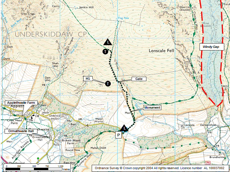
Car park OS grid ref: NY280253
Getting There
Approach via a minor road which branches off from the large roundabout at the junction of the A66 and the A591 north of Keswick. After 800m a very sharp right turn winds up to the Latrigg Gale rd car park.
Please park as tight as possible as this is a relatively small but very popular car parking area.
Do not park on the fell side of the gate at the end of the car park - there is no permission from the current owners.
You can drive through to drop gear off but do not leave your car there.
Getting to takeoff
Take the small gate at the SW end of the Gale Rd car park area and head north following the track past the monument and onto the slopes of Jenkin Hill.
Permission to use site
Mr Spedding at Mirehouse, John at Ormathwaite farm, George Birkett at Lonscale farm.
Flying
Hazards
Be aware of any wind gradient and keep well forward in strong conditions.
This is a south facing massif with large areas of scree/rock and deep gulleys which can create booming thermals in the right conditions - be ready!
Can be affected quite early by a sea breeze which can make conditions very rough - especially in the gulleys. This would come from the W/WNW along Bassenthwaite Lake and can make the site unusable.
There are many military aircraft in this area during the week. A CANP is advisable.
Take Off
For PG pilots; depending on the wind strength, the take off can be anywhere above the heather and below the summit cairn of Jenkin Hill. If the wind is light a slightly longer walk to the summit of Little Man can pay off.
Hangliders can take off just by the gate approx. half way up to Jenkin.
Landing Areas
OK to slope land on Jenkin Hill - beware of other wings taking off on busy days.
Best not to scratch the slope below the heather line, get to the landing field while you can.
The approved Jenkin Landing Field is to the left of the path to Jenkin as you leave the car park. It is a big field which we have permission to use even when it has stock in it - although keep well away from any sheep with lambs.
The field slopes downwards increasingly at its western end.
Be wary of the wind direction not being the same as on the hill you have just flown - although the site takes a southerly wind, the wind in the landing field may well flow from east or west through the small saddle between Latrigg and Skiddaw.
A windsock is useful here.
For a longer flight the Latrigg landing field is often used.
Flying
Hangliders - Can be quite a carry but well worth it. The HG take-off is just beyond the fell gate (1850' / 564m asl). An easy site to fly.
Avoid ground skimming due to ground nesting birds.
XC potential
Excellent potential both downwind and, in the right conditions, for achieving large triangle flights.
Keep well forward of windy gap if flying east towards Blease/Blencathra.

